
Lundin Peak/West Ridge
A short, class 3-4, route on generally sound rock. Views to the north and northeast include Glacier Peak, Mount Hinman, and Mount Thompson. Many climbers prefer to climb in the early season when snow covers brush and boulders on the approach. Times: 5-7 hr trailhead to summit. A great first alpine rock climb.
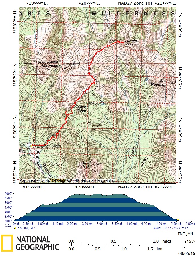
Getting There
Drive I-90 to Exit 52. Take the first left (Alpental Road) and the first right to the Pacific Crest Trail parking lot (3,040 ft).
APPROACH
A few minutes up the trail another valley appears on the left which leads to the south face of Lundin. Exit the trail a few hundred feet after the first right-turning switchback (approximately 4,340 ft), and make descending traverse (faint trail, some bushwacking) to the valley bottom. Ascend this valley to the right of the stream. Avoid the first rocky constriction by going over a hump on the left.
Continue through heavier brush to an open area below the second constriction. At the top of the gully, traverse to west ridge just left of south face (5,769 ft). Rope up at this point.
Alternative: An excellent late season alternative approach is from Alpental parking lot locate the unmarked Cave Ridge Trail 50 ft east of the Snow Lake trail head. A good climber's trail goes to, up, and over Cave Ridge. Continue on a gradual ascending traverse to Lundin Peak.
ASCENT ROUTE
The route stays to the north side of the ridge (class 3-4).
Climb a short step to a rocky point and descend 6 ft at a minor notch. Ascend a face on the north side of the steep step in the ridge, then follow the crest to the top. The summit (6,057 ft) is on the east end.
Alternative: Ascend a 60 ft face on the north side (low 5th class)
DESCENT ROUTE
Scramble down the east ridge for 100 ft to the top of a small cliff, from where a single rope rappel gains easy ledges at base. Continue down to notch in ridge from where an early season glissade can rejoin the ascent route.
Later in season scramble up short gully from glissade notch, continue east along left side of ridge top, along easy heather benches or rock slabs until ledges end. Step across narrow saddle onto right side of crest. Traverse to rock gully and scramble up to ridge crest and easy terrain. Walk down to Red-Lundin saddle, and pick up trail down to Commonwealth Basin, and the Pacific Crest Trail.
Alternative: Downclimb and rappel (one short rappel) the climbing route.
TRIP PROFILE
| SEGMENT | TIME (HR) | ELEVATION GAIN (FT) |
|---|---|---|
| Seattle to Trailhead | 1 | |
| Trailhead to Summit | 5-7 | 3,000 |
| Summit to Trailhead | 4-5 |
EQUIPMENT
Standard rock equipment.
NOTES
- Good in early season (snow, 1,500 ft glissade on hike out). Be ready for bushwhacking in late season, or take the Cave Ridge approach.
- The climb itself is short, generally on rock of good quality. Some variations are possible that can increase the difficulty of the climb.
- Commonwealth Basin approach has horrendous brush and steep scree/talus after snow gone.
information FOr leaders
Permit information
As of 2017, the Snoqualmie Ranger District considers Mountaineers trips and courses to be "nominal use". Leaders should print and copy this designation letter to show rangers they may see on trail.
- Suitable Activities: Climbing
- Climbing Category: Basic Alpine
- Seasons: May, June, July, August, September, October
- Weather: View weather forecast
- Difficulty: Basic Rock Climb, Strenuous 1, Technical 2, Basic Experience Climb
- Length: 9.5 mi
- Elevation Gain: 3,000 ft
- 6,057 ft
-
Land Manager:
Mount Baker-Snoqualmie National Forest
Alpine Lakes Wilderness, Snoqualmie Ranger District (MBSNF)
- Parking Permit Required: Northwest Forest Pass
- Recommended Party Size: 12
- Maximum Party Size: 12
- Maximum Route/Place Capacity: 12
- Green Trails Snoqualmie Pass No. 207
- USGS Snoqualmie Pass
| Name/Description |
|---|
| Lundin Peak Route Map |