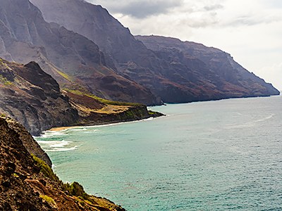
Kalalau Trail, Hawaii
A very strenuous backpack on the north shore of the island of Kauai in Hawaii.
on the trail
The Kalalau Trail is an 11 mile long trail along the north shore of the island of Kauai in Hawaii. It provides the only land access to the rugged and beautiful Na Pali coast. The trail begins at Ke'e Beach and traverses five valleys before ending at Kalalau Beach. Though the trail begins and ends at sea level, it crosses rugged ridges and valleys nearly constantly and has a total one-way elevation gain/loss of about 5,000 ft.
Because there are no other trails into the area, a trip to Kalalau Beach must be done has an out-and-back. Camping is allowed at only two places on the trail: Hanakoa, a small campground about 5.5 miles from the trailhead, and at Kalalau Beach, the terminus of the trail. Thus each leg of the trail (out and back) can be done either as a one day trek of 11 miles and 5,000 ft or as a two day trek with the distance and elevation gain split about equally across both days.
The route is famous for its scenery but also for its ruggedness and exposure. Though the route does not traverse any technical terrain, it does follow along some cliff edges and other steep drops at times. The amount of exposure is no greater than some of the strenuous hiking and backpacking routes in the Cascades, but hikers accustomed to rugged routes in the Pacific Northwest may find it disconcerting to see surf below them instead of snow or talus. Most consider the crux to be a brief section called "Crawler's Ledge" at mile 7 where the trail crosses over a narrow section of firm rock—care should be taken here especially if the trail is wet.
In addition to exposure, another potential hazard is the crossing of the Hanakapi'ai stream at mile 2, which can be dangerous if the stream is running high—heed the signs. Northwesterners will be glad to know there are no bears on the island, but there are occasional wild boars at Hanakoa so it is still important to prepare and store food at a distance from tent sites.
notes
- Learn more on the Hawaii DLNR Kalalau Trail web page, including a safety video and a trail brochure with a map.
- Suitable Activities: Backpacking
- Seasons: Year-round
- Weather: View weather forecast
- Difficulty: Very Strenuous
- Length: 22.0 mi
- Elevation Gain: 10,000 ft
- 820 ft
-
Land Manager:
State of Hawaii Department of Land & Natural Resources
Napali Coast State Wilderness Park
- Parking Permit Required: see Land Manager
- Recommended Party Size: 6
- Maximum Party Size: 12
- Maximum Route/Place Capacity: 12
- see Notes
There are no resources for this route/place. Log in and send us updates, images, or resources.
