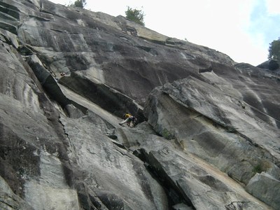
Index Town Walls
A popular rock climbing area near the town of Index, Washington off Highway 2. It's a great area for crag climbing, aid climbing and training.
Getting there
Take Highway 2 and turn off at Index-Galena road. Turn left onto the first bridge (5th St.) and take a left onto Index Ave. Follow it until the end, turning left again onto 2nd Ave. Take a right onto Avenue A and drive approximately half a mile. The parking area will be on the right.
climbing areas & routes
- Lower Town Wall
- Upper Town Wall Trail
- Upper Town Wall
- Lower Lump
- Inner Walls
- Lookout Point
- Zappa Wall
- Town Crier
- Green Drag-On
- Davis-Holland
Upper town wall Trail
2.6 miles round trip, 1,270 feet of elevation gain, difficulty: moderate/strenuous
Hike a short, but very steep climbers trail with cliffy dropoffs to views of the Skykomish River Valley, Mount Index, Baring Mountain, and Gunn and Merchant Peaks. It's one heck of a workout!
- Heavy use has eroded it in places and maintenance is minimal at best.
- Blue diamond markers show the best way to the summit, but be prepared to do some route-finding and scrambling to achieve the summit.
- You'll share the trail with climbers crawling over the cliffs. The proximity of this location to the town of Index makes this a popular location for climbers. See how many you can spot before or after you've completed your hike.
notes
- Guidebook Reference: The Index Town Walls by Chris Kalman & Matty Van Biene (Sharp End Publishing 2017).
- Guidebook Reference: Sky Valley Rock by Darryl Cramer (Sky Valley Press 2000).
Information for leaders
Scheduling & Permits
Please contact staff at info@mountaineers.org if you are leading a Mountaineers course field trip to Index Lower or Inner Town Walls, so that they can complete the permitting paperwork that is required by Washington Climbers Coalition (the land manager) for these areas. In order to allow for enough turnaround time on the permit, please notify staff at least 3 weeks ahead of your field trip.
As always, it is up to us to make sure we are being good land stewards and setting the standard for others to follow! Please keep group sizes to max of 12 total people and the number of Mountaineers groups to one per day.
- Suitable Activities: Climbing
- Seasons: Year-round
- Weather: View weather forecast
- Land Manager: Forks of the Sky State Park
- Parking Permit Required: None
- Recommended Party Size: 12
- Maximum Party Size: 15
- Maximum Route/Place Capacity: 12
- Green Trails Index No. 142
- USGS Index
This is a list of titles that represent the variations of trips you can take at this route/place. This includes side trips, extensions and peak combinations. Not seeing a title that fits your trip? Log in and send us updates, images, or resources.
- Lower Town Wall
- Upper Town Wall Trail
- Upper Town Wall
- Lower Lump
- Inner Walls
- Lookout Point
- Zappa Wall
There are no resources for this route/place. Log in and send us updates, images, or resources.
