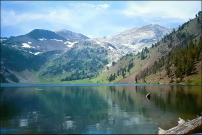
Ice Lake & Matterhorn
Backpack to and scramble the second highest peak in eastern Oregon's Wallowa Mountains and Eagle Cap Wilderness. This white limestone peak is perched along the Hurwal Divide with its west face towering 4,000 feet above the Hurricane Creek valley. It is 18 miles round trip and 5,300 feet of elevation gain and approached from the east via the Ice Lake Trail, a nice destination in its own right. A climber's boot track leads most of the way to the summit.
Getting There
Take Exit 261 off of I-84 and drive south on OR-82 to Joseph. Drive through Joseph staying on the highway, Main St in town, and continue as it becomes OR-351, Wallowa Lake Highway, to the Wallowa River Trailhead at the road's end in Wallowa Lake State Park (4,640 ft).
On the Trail
Ice Lake (7,848 ft)
15.6 Miles Round Trip, 3,500 feet of elevation gain
Hike 2.7 miles on the West Fork Wallowa River Trail, No. 1820, and turn right onto the Ice Lake Trail, No. 1808. Hike 4.3 miles to campsites at Ice Lake (7,748 ft).
The Matterhorn (9,826 ft)
18 miles round trip, 5,300 feet of elevation gain
From Ice Lake, find the climbers' boot path on the north shore of the lake and follow it to the summit of the Matterhorn (9,826 ft).
notes
- Guidebook: 100 Hikes / Travel Guide Eastern Oregon, 3rd ed. by William Sullivan (Navillus Press, 2015).
- Suitable Activities: Backpacking, Day Hiking, Scrambling
- Seasons: July, August, September, October
- Weather: View weather forecast
- Difficulty: Strenuous/Very Strenuous, Technical 2
- Length: 18.0 mi
- Elevation Gain: 5,300 ft
- 9,826 ft
-
Land Manager:
Wallowa-Whitman National Forest
Eagle Cap Wilderness, Eagle Cap Ranger District (WWNF)
- Parking Permit Required: Northwest Forest Pass
- Recommended Party Size: 6
- Maximum Party Size: 12
- Maximum Route/Place Capacity: 12
- Green Trails Wallowa Mountains No. 475SX
This is a list of titles that represent the variations of trips you can take at this route/place. This includes side trips, extensions and peak combinations. Not seeing a title that fits your trip? Log in and send us updates, images, or resources.
- Ice Lake
- Matterhorn
- Matterhorn (Oregon)
There are no resources for this route/place. Log in and send us updates, images, or resources.
