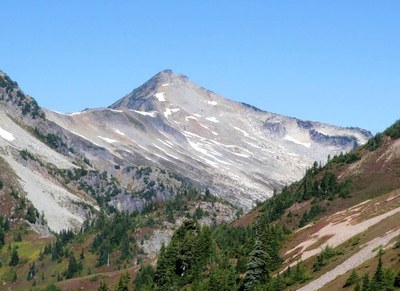
Hannegan Pass
Hike on trail above Ruth Creek through forest, cutting up to a high alpine pass with views in the North Cascades. From the pass, hike to the summit of Hannegan Peak or hike out Copper Ridge for spectacular ridge walking with views of the icy Pickett Range and peaks in all directions. Descend to the Chilliwack River walkign throgh miles of ancient trees and then back up to Whatcom Pass. Peel off the trail before the pass and scramble the very prominent but seldom-climbed Mount Chardonnay.
Getting There
Drive SR-542 13 miles past Glacier (get permits at the Glacier Visitor Center) and turn left onto Forest Road 32 (Hannegan Pass Road). Continue on Forest Road 32 for 5.3 miles to the Hannegan Pass trailhead at the road's end (3,120 ft).
on the trail
hannegan pass (5,066 ft)
9.2 miles round trip with 2,000 feet of elevation gain
Hike the Hannegan Pass Trail 4.1 miles to the turnoff for a campsite. Continue 0.5 miles to Hannegan Pass.
hannegan peak (6,187 ft)
11.4 miles round trip with 3,100 feet of elevation gain
Hike the Hannegan Pass Trail 4.1 miles to the turnoff for a campsite. Continue 0.5 miles to Hannegan Pass, and turn left to climb to the summit of Hannegan Peak.
copper ridge
20.4 miles round trip, 5,500 feet of elevation gain
Hike 4.1 mi to Hannegan Pass at 5,066 ft. Descend to the Copper Ridge and Chilliwack Trail junction. Take the left fork and follow Copper Ridge Trail to the look out at 6,260 ft. Along the way, there are campsites near the trailhead, Hannegan Pass, the Copper Ridge-Chilliwack junction, and Egg Lake.
- Enjoy a 2.2 mi round trip with 1,120 ft of elevation gain side trip to the top of Hannegan Peak at 6,186 ft.
- There are campsites at Copper Lake which is 1.2 mi and 1,000 ft elevation loss from the lookout.
- Extend your trip by descending to the Chilliwack River and continuing north or south.
- Make this a loop trip by returning to Hannegan Pass by hiking the Chiliwack Trail the with an optional ride on the hand-operated cable car across the Chilliwack River. The added mileage and elevation loss and gain make this a slightly longer and more difficult trip.
Copper Ridge & Whatcom Pass Loop
44-mile loop, 15,000 feet of elevation gain
This loop hike features a 5-mile walk along Copper Ridge with panoramic mountain views, followed by a steep descent to the Chilliwack River drainage with miles of ancient trees, then back up to camp at Whatcom Pass with views of Challenger Glacier before heading back. This trip will earn you bragging rights with its 15,000 feet of gain and 12,260 feet of loss!
Suggested Itinerary
- Day 1: Hike 8 miles and 3,600 feet of elevation gain from the Hannegan Pass Trailhead to Silesia Camp. Enjoy great views from the campsite. From camp, hike 0.6 mile round trip to Egg Lake for water.
- Day 2: Hike 2 miles to Copper Mountain Lookout for an extended break to take in the views. Then, ramble along Copper Ridge for another 4.5 miles before descending steep switchbacks to the Chilliwack River. Ford the river and hike to Indian Camp. It's 11.5 miles total with a 2,000 feet of elevation gain and 5,270 feet of elevation loss. This is the toughest day.
- Day 3: Hike 8 miles and 3,300 feet of elevation gain from Indian Camp through ancient forests to Whatcom Pass. Marvel at the views of Challenger Glacier.
- Day 4: Began hiking back through the valley to US Cabin Camp. It's ~6.5 miles, 3,000 feet of elevation loss, and 2,900 feet of elevation gain.
- Day 5: Hike out to the Hannegan Trailhead for a total of 9.6 miles with 2,900 feet of elevation gain and 2,400 feet of elevation loss.
approach & ascent
Mount Chardonnay (7,020 ft)
9 miles round trip, 4,400 feet of elevation gain
difficulty: Strenuous 4, Technical 4
Hike the Hannegan Pass Trail for ~1.5 miles, then ascends off-trail to the north, aiming for the saddle just northwest of Granite Mountain. From the saddle, follow the ridge north for ~1.5 miles to the summit. Mount Chardonnay is an unofficial name, not found on maps. Consider scrambling Granite Mountain (6,688 ft) too.
- Suitable Activities: Backpacking
- Seasons: July, August, September, October
- Weather: View weather forecast
- Difficulty: Strenuous
- Length: 9.2 mi
- Elevation Gain: 2,000 ft
- 5,066 ft
-
Land Manager:
Mount Baker-Snoqualmie National Forest
Mount Baker Wilderness, Mount Baker Ranger District (MBSNF)
- Parking Permit Required: Northwest Forest Pass
- Recommended Party Size: 12
- Maximum Party Size: 12
- Maximum Route/Place Capacity: 12
- Green Trails Mt Shuksan No. 14
- Green Trails Mt Challenger No. 15
- Green Trails Mount Baker Wilderness Climbing No. 13SX
- Green Trails North Cascades Ross Lake No. 16SX
- Trails Illustrated North Cascades National Park
This is a list of titles that represent the variations of trips you can take at this route/place. This includes side trips, extensions and peak combinations. Not seeing a title that fits your trip? Log in and send us updates, images, or resources.
- Copper Ridge
- Hannegan Peak
- Copper Ridge & Whatcom Pass Loop
- Mount Chardonnay
- Granite Mountain
- Granite Mountain (Hannegan Pass)
- Mount Chardonnay & Granite Mountain
There are no resources for this route/place. Log in and send us updates, images, or resources.
