
Hall Creek
A short, scenic beginner canyon, rated v4a3I in low to moderate flows
GETTING THERE
Take Exit 38 off of I-90 in North Bend. Turn north and then continue straight (do not turn right again into the Olallie State Park parking lot). After passing a dirt parking area on the left, cross the small bridge over Hall Creek. Park in Olallie State Park on the left if you have a Discover Pass, you can park in the State Park. Otherwise, there is a dirt pullout on the right which can hold 3-4 cars. The trail begins just on the other side of the gate.
APPROACH
From the gate, follow the trail, which parallels the creek for a while. The trail will begin climbing steep stone steps, then switchbacking towards the Palouse to Cascades State Park Trail (formerly known as the John Wayne Trail or Iron Horse Trail). At the junction, turn right to stay on the Hall Point Trail. This trail has several forks. The first fork to the right will take you to the bottom of Hall Creek Falls, a short diversion that can be useful for checking out the water levels. Continue on the main trail, continuing to switchback up, and away from the creek. At the next fork, take the right hand fork that heads down and back towards the creek. The trail will peter out when you reach the top of the technical section. The approach takes 30-45 minutes.
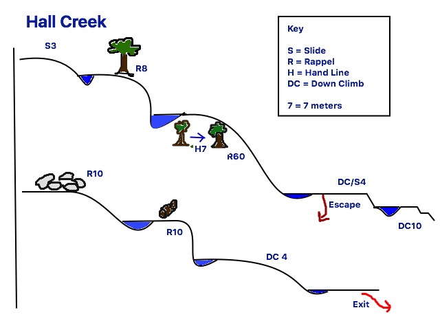
DESCENT
Head downstream on very slippery granite. (note that above the main technical section, there are anchors at the top of an optional 10' falls that can be useful for teaching beginners) In about 500' you'll encounter a fun, 15' slide DCL (down canyon left). Continue down on slippery granite to the top of the first rappel.
- Rappel 1: 18 feet (6m) - natural anchors DCL (Down Canyon Left) into a pool
- Rappel 2: 170 feet (55m) natural anchors DCR (Down Canyon Right). Consider protecting the access to the anchor with a hand line. This is a long, low-angle rappel on slippery rock that can be done as a controlled slide (on rappel).
- Down Climb or Slide: 12 feet (4m)
- Round the corner to a partner-assist down climb DCR, or bushwhack to an easy down climb DCL, then continue down canyon carefully.
- Down Climb: 30 feet (10m) on tricky terrain
- Rappel 3: 30 feet (10m) DCL. Webbing anchors in a boulder pinch. Check the webbing as this is in the watercourse. Alternatively, a dry rappel off a tree DCR is an option. If possible, use a retrievable system so as not to leave webbing behind—this is a very visible tree.
- Rappel 4: 30 feet (10m) off a log. This is a short fun rappel in the flow.
- Continue down canyon for another 5-10 minutes. The exit is an obvious path on the right.
EXIT
Several hundred feet of creek walking and down climbing after the final rappel, the exit trail will appear on the right. Keep an eye out because its easy to miss, but it is a very clear trail (no bushwhacking). This trail connects with the main trail at the bottom of the stone steps, and is about a 5-10 minute easy walk to the car.
EQUIPMENT
Standard canyoning gear including replacement webbing and quick links. This is an open canyon and gets full sun, so on hot days a shortie or farmer john wetsuit may be sufficient.
TRIP PROFILE
- Rappels: 4
- Longest Rappel: 170 feet
- Approach: ~1.5 miles
- Exit: ~0.25 mile
- Time: 3-4 hours total
NOTES
- This canyon is rated v4a3I at moderate-low water levels, and v4a4I in high water. It is rated v4 because there is a rappel over 30m, but because that rappel is low angle and the canyon is generally beginner-friendly, we rate it as a Basic Canyon.
Information for Leaders
Scheduling
This route allows multiple bookings. Please check scheduled trips listed below in the "Activities" tab to see if there is another group already booked on the same day. Leaders are expected to contact the leader(s) of existing trips to ensure there are no concerns or conflicts, according to The Mountaineers Outdoor Ethics Policy. Please review our Group Size & Multiple Bookings page for guidance.
Permits
As of 2017, the Snoqualmie Ranger District considers Mountaineers trips and courses to be "nominal use". Leaders should print and copy this designation letter to show rangers they may see on trail or carry a digital copy on their phone.
- Suitable Activities: Canyoning
- Seasons: July, August, September
- Weather: View weather forecast
- Difficulty: Basic Canyon
- Length: 2.0 mi
- Elevation Gain: 550 ft
-
Land Manager:
Mount Baker-Snoqualmie National Forest
Snoqualmie Ranger District (MBSNF)
- Parking Permit Required: Discover Pass
- Recommended Party Size: 6
- Maximum Party Size: 30
- Maximum Route/Place Capacity: 24
- Green Trails Mount Si NRCA No. 206S
| Name/Description |
|---|
| hall_creek_topo.jpg |
| Hall Creek Ropewiki Link Link to ropewiki page |