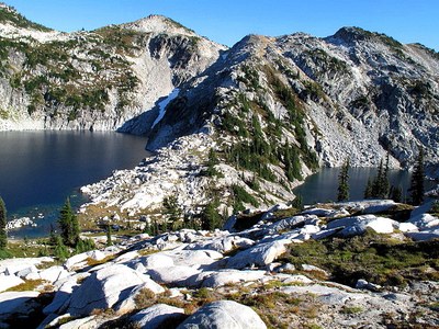
Granite Mountain & Trico Mountain
Midway between Stevens Pass and Salmon La Sac lays the other Granite Mountain. A longer drive and a lot longer hike, but the reward is a terrific scramble above a lovely lake. Along with Trico, (think “Tri-County”), make for a great two day trip or one very long day.
ASCENT ROUTE
Hike up Deception Pass trail to Hyas Lake. At approximately 4.3 mi (4,200 ft) go right (east) on Tuck and Robin Lakes Trail. Trail is maintained, obvious, and signed. Trail contours to southeast about 1/2 mi, then abruptly turns northeast and climbs steeply to Tuck Lake (5,268 ft). Follow boot track around right side of Tuck Lake, then generally east up ridge to Robin Lakes (6,163 ft). Camping is available at either Tuck or Robin Lakes. Note these are popular backpacking destinations.
Route to Granite Mountain
The real scramble starts at the outlet of upper Robin Lake. Head up the ridge southeast ridge toward the west peaks. Include those if you have time, otherwise traverse left into the gully that tops out at 6,750 ft. From that saddle, ascend east to the north peak and then south to the true summit 7,144 ft.
If you have two days, include a side trip to the 6,900 ft ridge 500 yards west of the true summit on the way up.
If you have plenty of time and/or energy, rather than descending the same route, circle counterclockwise around upper Robin Lake. The ridge and west slopes east of Robin Lake go just fine.
Route to Trico Mountain
From Robin Lakes, the route to Trico is simply to follow the county line north-northwest past upper Granite Mountain Pothole, then up the ridge to the summit. Most of the route is above trees and is easy to follow.
From the outlet of Tuck Lake, the route to Trico is the head due north along the other county line which takes you up a forested ridge to the summit.
NOTES
The Strenuous rating assumes these peaks are scrambled over two days. For a single day, car camp at the trailhead on Friday night and plan on a 12-14 hr day.
FOr leaders
Permit information
As of 2017, the Snoqualmie Ranger District considers Mountaineers trips and courses to be "nominal use". Leaders should print and copy this designation letter to show rangers they may see on trail or carry a digital copy on their phone.
- Suitable Activities: Scrambling
- Seasons: July, August, September
- Weather: View weather forecast
- Difficulty: Technical 3, Strenuous 4
- Length: 17.0 mi
- Elevation Gain: 4,400 ft
- 7,144 ft
-
Land Manager:
Mount Baker-Snoqualmie National Forest
Alpine Lakes Wilderness, Snoqualmie Ranger District (MBSNF)
- Parking Permit Required: Northwest Forest Pass
- Recommended Party Size: 12
- Maximum Party Size: 12
- Maximum Route/Place Capacity: 12
- Green Trails Alpine Lakes West (Stevens Pass) No. 176S
- USGS Mt Daniel
- USGS The Cradle
There are no resources for this route/place. Log in and send us updates, images, or resources.
