Goat Peak (Snoqualmie)
A short, but fairly intense, hike that leads to an abandoned fire lookout site above Easton. It's 6 miles round trip with 2,200 feet of elevation gain.
getting there
Take Exit 71 off of I-90, turn south, drive through the stop sign and over the railroad grade and John Wayne Trail. This street turns right (about 0.2 miles from Exit 71) and is signed as the Cabin Creek Road. At 2.8 miles from Exit 71, the road swings to the left and the pavement ends and the road is signed as Forest Road 41. Follow this good gravel road until at 3.3 miles from Exit 71, an unsigned dirt road bears off to the left. Turn onto this high clearance dirt road which has many pot holes and some sharp rocky sections. Some of the first part of it has the alders and willows growing in narrowing it to one narrow lane. Reach the trailhead (2,780 ft) at 6.7 miles from Exit 71. Drive a little past the trailhead, turn around, and park along the edge of the road.
on the trail
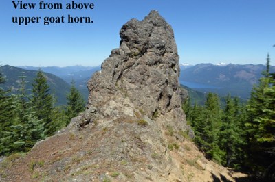
Hike up the steep and sometimes rocky multi-use trail to the abandoned forest fire lookout site atop Goat Peak above Easton. The trail passes the rocky Goat Horns which can be seen from I-90 far below. As you near the top of the wooded trail, views to the north including lakes in the Yakima River Valley below, the Stuart Range and other peaks open up.
- Suitable Activities: Day Hiking
- Seasons: May, June, July, August, September, October
- Weather: View weather forecast
- Difficulty: Moderate
- Length: 6.0 mi
- Elevation Gain: 2,200 ft
- 4,981 ft
-
Land Manager:
Okanogan-Wenatchee National Forests
Cle Elum Ranger District (OWNF)
- Parking Permit Required: Northwest Forest Pass
- Recommended Party Size: 12
- Maximum Party Size: 12
- Maximum Route/Place Capacity: 12
- Green Trails Easton No. 240
This is a list of titles that represent the variations of trips you can take at this route/place. This includes side trips, extensions and peak combinations. Not seeing a title that fits your trip? Log in and send us updates, images, or resources.
- Goat Peak
There are no resources for this route/place. Log in and send us updates, images, or resources.
