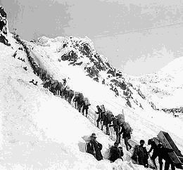
Backpack Alaska's Chilkoot Trail
Relive the experience of the Klondike gold miners as you retrace their route on a five-day, 33-mile backpack adventure up and over the Chilkoot Pass (~6,800 feet elevation gain). Explore historic Skagway, Alaska (near the start of the trail) and enjoy a ride from the trail's end at Lake Bennett back to Skagway on the classic White Pass-Yukon Narrow-Gauge Railway.
The Chilkoot Trail is a 33-mile historic trail through the Coast Mountains that leads from the now abandoned townsite of Dyea, Alaska, over 3525-foot Chilkoot Pass, to Bennett, British Columbia, now protected as part of the Klondike Gold Rush International Historical Park. The trail was long used by Tlingit Indians as a trade route to the interior, and later by explorers and prospectors. The Klondike Gold Rush (1896–1899) transformed the Trail into a mainstream transportation route to the Yukon River and from there to gold fields in the Yukon.. Of the several overland routes, the Chilkoot Trail was the most direct and least expensive, so soon was also the most popular. A railway was built in 1899 from Skagway along the parallel White Pass trail, and the Chilkoot Trail soon was abandoned by prospectors but has later become a popular tourist trail. To prevent overuse and maintain the remote character of the trail, a permit system limits access to no more than 50 backpackers beginning the trail each day.
The gateway to the Chilkoot Trail is Skagway Alaska, a boomtown during the Klondike Gold Rush and now a bustling tourist town and cruise-ship destination. Modern Skagway hosts an extensive historic district and a full range of services for hikers. The Chilkoot trail begins in Dyea, Alaska, a short shuttle journey from Skagway. The trail has twelve 'legs' or sections and several camp options. The first part of the trail passes through lush temperate rainforest full of huge cottonwoods, edible berries, and colorful wildflowers, and abandoned historic artifacts. Views begin to increase as hikers approach Sheep Camp, where a ranger gives a nightly presentation on the history of the pass and current weather and trail conditions. The most difficult part of the trail ascends steeply from Sheep Camp over boulderfields and up a very steep gully (the "Golden Stairs") through a litter of boulders, scree and prospectors' old abandoned gear, to the pass 3000 feet above. From there the trail eases and passes along Crater Lake and Bare Loon Lake, a great section to spot golden eagles, waterfowl and even bears. Finally the last section of trail reaches Lake Bennett where the Yukon River and the White Pass-Yukon Railroad intersect the trail. In Bennett, you can reward yourself with a hot meal at the historic Bennett Eating House.
A variety of transportation choices are available to get to Skagway from Seattle, including float plane, fast ferry to Juneau for commercial flights, and the slower Alaska Marine Highway ferry which travels down the Inside Passage to Bellingham. (It is permissible to pitch tents on the deck of the ferry and sightsee and relax through the four day trip.)
- Suitable Activities: Global Adventures
- Seasons: June, July, August
- Weather: View weather forecast
- Difficulty: Strenuous
- Length: 33.0 mi
- Land Manager: Land Manager Varies
- Parking Permit Required: see Land Manager
- Recommended Party Size: 12
- Maximum Party Size: 12
- Maximum Route/Place Capacity: 12
There are no resources for this route/place. Log in and send us updates, images, or resources.
