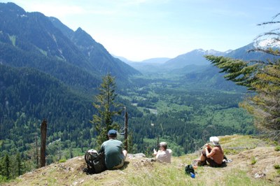
Garfield Ledges
This short trail in the Middle Fork Snoqualmie River valley offers sweeping views of the valley within an hour’s drive of Seattle. It's 2.2 miles round trip with 630 feet of elevation gain.
getting there
Take Exit 34 off of I-90 and turn left onto 468th Ave SE. Drive 0.6 miles to the junction with SE Middle Fork Road, turn right, and drive SE Middle Fork Road 2.1 miles. Bear left at the fork onto Forest Road 56. Drive 11.5 miles to the Garfield Ledges Trailhead (1,100 ft).
on the trail
The Garfield Ledges trail, built as a partnership between the Mountains to Sound Greenway Trust and the Washington Trails association, offers panoramic views of the Middle Fork Snoqualmie River valley for a short drive from Seattle and a short hike.
information for leaders
Scheduling
- If you are scheduling this as a non-stewardship related activity, please limit your group size to the recommended party size. The maximum party size is for use by stewardship trips only, and includes both participants and leaders. Group size maximums do not reflect how stewardship trips are run (in smaller groups of participants and leaders), but allow for leaders to register the activity in our system.
PermitS
- As of 2017, the Snoqualmie Ranger District considers Mountaineers trips and courses to be "nominal use". Leaders should print and copy this designation letter to show rangers they may see on trail or carry a digital copy on their phone.
- Suitable Activities: Day Hiking
- Seasons: Year-round
- Weather: View weather forecast
- Difficulty: Easy
- Length: 2.2 mi
- Elevation Gain: 630 ft
- 1,860 ft
-
Land Manager:
Mount Baker-Snoqualmie National Forest
Snoqualmie Ranger District (MBSNF)
- Parking Permit Required: Northwest Forest Pass
- Recommended Party Size: 12
- Maximum Party Size: 20
- Maximum Route/Place Capacity: 20
- Green Trails Middle Fork Snoqualmie No. 174SX
This is a list of titles that represent the variations of trips you can take at this route/place. This includes side trips, extensions and peak combinations. Not seeing a title that fits your trip? Log in and send us updates, images, or resources.
- Oxbow Loop & Garfield Ledges
There are no resources for this route/place. Log in and send us updates, images, or resources.
