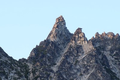
The High Priest/North Face
The High Priest is a prominent white tower located on the main Temple Ridge crest in the Enchantments. The North Face is a basic rock climb rated 5.5.
getting there
From US-2 in Leavenworth, turn onto Icicle Creek Road. Drive about 4 mi to the Snow Lakes Trail parking lot.
Approach
Take Snow Lakes Trail (No. 1553, 1,400ft) to Nada Lake (5.2 mi). Go about 0.5 mi. on right side of the lake, cross Nada Creek and head up hill just left of the talus slope toward the notch leading to Temple Canyon. Where the talus slope narrows to about 75 feet, work right on a Class 3 ledge, then up slabs to a level area just left of the stream. Follow a steep dirt and rock trail into Temple Canyon. Follow a way trail, generally right of the stream, to near the end of Temple Canyon. Scramble up left onto the broad plateau of Tamarack Meadows where good camping is found. Temple is at the east end of the ridge, the sharp peak just left of a crag which appears higher. High Priest is further west, in the middle of the ridge. It has a steep but featured north face, a left-facing open book which splits the right one-third of the face, and a small, blocky summit. At the very highest point of Tamarack meadows, when Prusik Pass is visible to the west, High Priest is the dramatic pinnacle in your face to the south.
Alternate Approach: From Enchantment Basin travel through Prusik Pass, then traverse about 0.4 mi east to the base of route. If descending back to Enchantment Basin: after the 60-foot rappel to the saddle, descend down a west trending gully on the south slope for a few hundred feet. As the gully curves left, scramble up to a rib and drop into the next gully to the west. Descend this broad gully into Enchantment Basin, staying to the right to avoid cliffs.
Climbing Route
Ascend the gully between High Priest and the crag just to its east for about 50 feet. Then work right (Class 2) onto a wide bench with a few small trees, the highest trees on the face. Starting from the left side of the bench, climb three fairly long pitches (variations possible), staying mostly on the left side of the face, ending about 30 feet below the summit. Move left around the south side of a large block, then climb it, passing a small roof; then climb a short crack up and right to the final summit block.
Descent
Either downclimb or rappel 20 feet on the southeast face; then climb over a rib and down to a rappel anchor (fixed pitons) about 30' below and E of the summit. Do a 60' rappel into the saddle between the High Priest and the crag to its east. Cross the saddle completely, until you see a descending traverse down obvious blocks onto the north slope of the crag to the east (Class 3). Continue down and across the north slope (Class 2), working generally to the east. Do not descend the gully below and north of the saddle - watch for loose rock.
TRIP PROFILE
| SEGMENT | TIME (HOURS) | ELEVATION GAIN (FEET) |
|---|---|---|
| Seattle to Trailhead | 3 | |
| Trailhead to Camp | 6-8 | 5,600 |
| Camp to Summit | 2-4 | 1,240 |
| Summit to Camp | 1-2 | |
| Camp to Trailhead | 4-5 |
Notes
- An excellent rock climb - 4 good pitches of mixed 4th & 5th class. The rock is generally sound, with good protection, but beware of several large, loose blocks.
- The hike in is very long and strenuous.
- On a three-day weekend most parties climb The High Priest and Mount Temple the same day, climbing High Priest first, then doing a low traverse to Mount Temple. On a two-day weekend an average party will not do both climbs.
Photo by Rob Busack on July 3, 2023.
- Suitable Activities: Climbing
- Climbing Category: Basic Alpine
- Seasons: June, July, August, September, October
- Weather: View weather forecast
- Difficulty: Technical 5, Strenuous 3, Basic Rock Climb, Basic Experience Climb
- Length: 14.0 mi
- Elevation Gain: 6,840 ft
- 8,240 ft
-
Land Manager:
Mount Baker-Snoqualmie National Forest
The Enchantments, Wenatchee River Ranger District (OWNF)
- Parking Permit Required: Northwest Forest Pass
- Recommended Party Size: 8
- Maximum Party Size: 8
- Maximum Route/Place Capacity: 8
- Green Trails Alpine Lakes East (Stuart Range) No. 208SX
- USGS Enchantment Lakes
- Green Trails Enchantment Lakes No. 209S
There are no resources for this route/place. Log in and send us updates, images, or resources.
