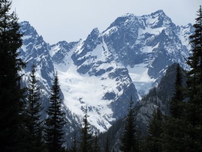
Mount Stuart/Sherpa Glacier
Early season climb basic glacier of the north side of Mount Stuart approach through The Enchantments in the Alpine Lakes Wilderness. April and May are ideal times partly because permits for The Enchantments are not required until June. The couloir reaches steepness about 40 degrees.
getting there
Drive US-2 east to Leavenworth. Just before entering town, turn right on Icicle Creek Road. Drive 8.5 miles to Bridge Creek Campground. Turn left and drive through campground, cross the river to Eightmile Creek Road (Forest Road 7601). Drive 4 miles to the Lake Stuart Trailhead (3,600 ft).
approach
Begin at the Lake Stuart-Colchuck Lake Trail (No. 1599). At ~2.2 mi (4,500 ft) there is a fork. The left goes to Colchuck Lake, right goes to Lake Stuart. Continue on the Stuart Lake trail through the beaver meadows. In another 1.5 mi, reach the first switchback. Leave the trail here to the left (south) finding an obscure climbers' trail.
Cross the Stuart Lake creek over logs. This trail has not been maintained in decade. It is riddled with blowdown, re-routes, questionable cairnes, and is hard to follow. Generally follow along Mountaineers Creek, with it on your left. Do not follow the cairnes into the bouldfield (4,675 ft at UTM NAD27 10 T 661036 5261934), but rather, stay low along the creek.
Follow a creek up the Sherpa/Ice Cliffs Glaciers drainage. As you ascend, that creek will be on your left. Be sure to keep the creek in sight/earshot on the way down. Obtain the bench at 5,400 ft. One could find good camping in the wood, however, continuing further to a boulderfield obtains great camp areas near water (depending on snowpack). A little further, camp could be set at the base of the glacier allowing ropes, harnesses, and prusiks to be setup the night before.
ascent route
Ascend the Sherpa Glacier directly. Find the best route either to the left, or right of the lower rock island. The right is more direct and climbable. Continue up the right (westerly) couloir. As it steepens, place pickets as necessary. Follow the dogleg right to the top of the couloir. From the top of the couloir, continue up, west, along the ridge to the false summit, then true summit. Along the way, pass the Cascadian Couloir.
descent route
Descend the climbing route.
TRIP PROFILE
| SEGMENT | Miles | Elevation Gain (FT) | Time(HR) |
|---|---|---|---|
| Trailhead to Camp | 6.1 | 2,000 | 4 |
| Camp to Summit | 2.0 | 4,000 | 6-8 |
| Summit to Trailhead | 8.1 | 7-8 |
EQUIPMENT
Standard glacier equipment and helmet. Pickets for running belay. Provisional ice screws.
notes
- Approach via The Enchantments before permits required in June.
- Depending on snowpack, approach may be via climbers trail as described, or over snow.
- Suitable Activities: Climbing
- Climbing Category: Basic Alpine
- Seasons: March, April, May, June
- Weather: View weather forecast
- Difficulty: Basic Glacier Climb, Basic Experience Climb
- Length: 16.2 mi
- Elevation Gain: 5,833 ft
- 9,415 ft
-
Land Manager:
Okanogan-Wenatchee National Forests
The Enchantments, Cle Elum Ranger District (OWNF)
- Parking Permit Required: Northwest Forest Pass
- Recommended Party Size: 8
- Maximum Party Size: 8
- Maximum Route/Place Capacity: 8
- Green Trails The Enchantments No. 209S
- Green Trails Alpine Lakes East (Stuart Range) No. 208SX
- USGS Mount Stuart
- USGS Enchantment Lakes
- USGS Cashmere Mtn
There are no resources for this route/place. Log in and send us updates, images, or resources.
