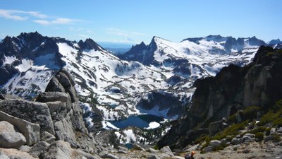
Edwards Mesa-Enchantments Traverse
A very beautiful, very strenuous, and comprehensive tour of the upper Enchantments for very experienced scramblers with a high level of conditioning. The 8,000 foot elevation gain of this trip sees it all via the seldom visited Toketie Lake, Toketie Pass, Pogo Col, upper Enchantment Lakes, Aasgard Pass, and Lake Colchuck.
getting there
stuart lake trailhead
From SR 2 in Leavenworth drive Icicle Creek Road (Forest Road 76) for 8.4 miles. Turn left on Eightmile Road (Forest Road 7601), about one mile past Eightmile Campground and signed Lake Stuart/Colchuck Lake. Continue 3.8 miles to the trailhead (3,400 ft).
snow lake trailhead
From SR 2 in Leavenworth drive Icicle Creek Road (Forest Road 76) drive 4.2 miles to the trailhead and large parking lot on the left (south) side of the road (1,350 ft).
APROACH, ASCENT, & DESCENT
Hike the Snow Lakes Trail (No. 1553, 1,400ft) for ~3.5 miles to the ~2,900-foot elevation. Cross Snow Creek taking advantage of any logs that might be present to reach the base of a boulder slope/rock slide. This slide allows access to the steep basin that is south of and runs parallel to the Toketie Creek drainage (a ridge of gendarmes separates them). Ascend the rock slide and steep alps (trending to the left) to reach Toketie lake (4.8 mi, 6,200 ft). From the lake continue up valley on the northern side to avoid old avalanche debris from Three Musketeers Ridge to reach Toketie Pass (5.8 mi, ~6,800 ft). At the pass ascend the ridge crest trending SSW (becoming S) that separates the Shield Lake drainage from Tamarack Meadows to reach Pogo Col (7.0 mi, ~8,200 ft). From Pogo Col descend steep terrain in a very deliberate manner to avoid short cliffs on your way to rejoining the upper Enchantments boot track/trail at the outlet of Lake Viviane (7.7 mi, 6,800 ft). Continue ascending through the Enchantments to reach Aasgard Pass (10.2 mi, ~7,800 ft). Descend the standard route from Aasgard Pass to reach the Lake Colchuck outlet (11.8 mi, 5,600 ft) and the Lake Colchuck trailhead (15.4 mi, 3,400 ft).
NOTES
- In order to maximize the enjoyment of this trip it is highly recommended to spend the evenings preceding and following this trip in the Leavenworth area. Doing so allows a very early start and an ascent of the south facing slope leading to Toketie Lake when temperatures are less daunting. Traveling to the Leavenworth area the day before the trip also allows a car to be staged at the Lake Colchuck Trailhead, making even more daylight hours available for the trip.
- Although this trip could be done in the reverse direction (with an apparent reduction in total elevation gain of ~2,200 feet), it is not recommended. A descent of the infrequently traveled, steep, and brushy slope between Toketie lake and the Snow Lakes trail (which includes a non-trivial stream crossing) would be very challenging at the end of a very long day with daylight rapidly waning.
- Suitable Activities: Scrambling
- Seasons: August, September
- Weather: View weather forecast
- Difficulty: Strenuous 5, Technical 4
- Length: 15.4 None
- Elevation Gain: 8,000 ft
- 8,200 ft
-
Land Manager:
Okanogan-Wenatchee National Forests
The Enchantments, Cle Elum Ranger District (OWNF)
- Parking Permit Required: Northwest Forest Pass
- Recommended Party Size: 8
- Maximum Party Size: 8
- Maximum Route/Place Capacity: 8
- USGS Jack Ridge
- USGS Cashmere Mtn
- USGS Blewett
- Green Trails Enchantment Lakes No. 209S
- Green Trails Alpine Lakes East (Stuart Range) No. 208SX
- USGS Enchantment Lakes
There are no resources for this route/place. Log in and send us updates, images, or resources.
