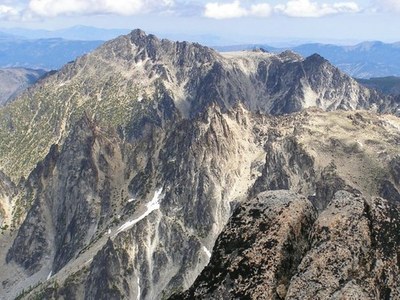
Cannon Mountain/Northslope Approach
Cannon Mountain at 8,638 ft is the 38th of the 100 highest peaks in Washington. It may be the most unknown mountain of this stature in the Enchantment region and probably the most neglected. Although it is one of the major peaks of the region and rising higher than its cross canyon neighbor, Cashmere Mountain, it is concealed from nearly every lowland vantage.
Geting There
Drive US-2 to Leavenworth and turn onto Icicle Creek Road of Icicle at the west ens of town. Turn left at the Bridge Creek campground just after Milepost 11 and continue on Forest Road 7601 crossing a bridge over the Icicle River and continue for almost 4 miles until the road ends at the Stuart Lake and Colchuck Lake Trailhead.
Approach & Ascent
Follow the old logging road from the trailhead to its end. Then head north to Coney Lake at 7,400 ft. From the lake, ascend southwest up a snow-filled gully to Druid Plateau east of the summit. Scramble the ridge to the friction slab that leads to the summit.
notes
- There are no trails to Cannon Mountain and getting to it involves significant cross country travel, initially through thick, steep brush, then steep snow, then a challenging ridge scramble to the summit block which is a friction slab.
- This scramble is for those who are very fit with extensive experience in all scrambling skills and with the fortitude to work through a goodly amount of miserable brush bashing and dead-fall hopping.
- Generally the earliest would be late May (avalanche danger in high snow years) but normally by late June through late October (depending of course on the weather)
- All the routes into the Cannon Mountain area are feasible. The North Couloir variation route that is off of Northwest Ridge gives the possibility of an early season hike/climb depending on if any avalanche danger is present.
- Suitable Activities: Scrambling
- Seasons: May, June, July, August, September, October
- Weather: View weather forecast
- Difficulty: Strenuous 5, Technical 4
- Length: 12.0 mi
- Elevation Gain: 5,238 ft
- 8,638 ft
-
Land Manager:
Okanogan-Wenatchee National Forests
The Enchantments, Wenatchee River Ranger District (OWNF)
- Parking Permit Required: Northwest Forest Pass
- Recommended Party Size: 8
- Maximum Party Size: 8
- Maximum Route/Place Capacity: 8
- Green Trails Alpine Lakes East (Stuart Range) No. 208SX
- USGS Cashmere
There are no resources for this route/place. Log in and send us updates, images, or resources.
