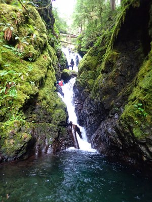
Clark Creek
An early season Basic Canyon located in the Wynoochee River Valley. This canyon is usually run in July, and is rated v3a3III.
Getting there
Drive SR-12 to Montesano, the last stop for fuel and other supplies before heading north. Drive Wynoochee Valley Road north for 33 miles until it abruptly turns to gravel and becomes Forest Road 2312. Continue another 9.7 miles, turn left and cross the Wynoochee River. Clark Creek is less than a minute up the road on the left. There are spots both above and below where the road crosses Clark Creek to park multiple vehicles. The best spot is just downhill from the creek, though it is often taken by campers. In a pinch, park at the "T" junction just before the road crosses the Wynoochee River.
approach
Not too far on the downhill (east) side of the creek, look for an open space to enter the forest. A faint use trail meanders up the hillside. It is marked occasionally with old flagging tape, but not consistently. At several points it's easy to wander off the way trail, but the forest is not very thick or brushy in most places and it's usually to find it again. Reach an overgrown but obvious forest road at around 2,000 ft. Bushwhack on the road to the creek which just below Rappel 0. Skip the fikrst rappel or head up from the forest road into the forest and traverse until reaching a good place to descend the hillside to the creek above Rappel 0.
descent
The descent features 10-11 rappels, some with challenging rigging, a very unique rooster tail, and a nice narrows. The rooster tail can be bypassed by downclimbing around it, but at moderate flows it’s fun to rappel! An easy exit exists canyon left just before the narrows if the flow is too high.
exit
The final rappel ends at the road. Climb up the side of the culvert to the road and walk to the cars.
equipment
Standard canyoning equipment. This creek uses a lot of natural anchors and may change a bit each year, so bring plenty of anchor material.
trip profile
- Rappels: 10-11
- Longest Rappel: 130 feet
- Approach: 25-45 minutes
- Exit: 100 feet
- Time: 4-6 hours
Notes
- Recent beta and community trip reports can be found on ropewiki.com's Clark Creek web page.
- This canyon is usually run in July, and is rated v3a3III.
- Suitable Activities: Canyoning
- Seasons: July, August
- Weather: View weather forecast
- Length: 0.6 mi
- Elevation Gain: 610 ft
- 2,140 ft
-
Land Manager:
Olympic National Forest
Pacific Ranger District (ONF)
- Parking Permit Required: None
- Recommended Party Size: 8
- Maximum Party Size: 12
- Maximum Route/Place Capacity: 12
There are no resources for this route/place. Log in and send us updates, images, or resources.
