Chuckanut Bay
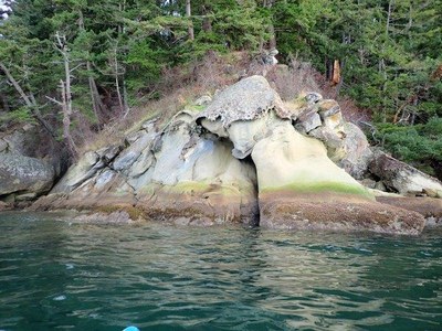
Sea kayaking in Puget Sound's Chuckanut near Bellingham is a relaxing paddle with good scenery and possible wildlife sightings. And Larrabee state park and Chuckanut Bay are famous for the sandstone rock formations.
Launch Points
- Boulevard Park
- Harris Street Boat Ramp, Fairhaven
- Marine Park
- Chuckanut Bay Shorelands
- Larrabee State Park boat launch. A Discover pass is required to park here, there is a bathroom, and the launching beach is close by and protected.
On the Water
The route is along the shore is straightforward. The best rock formations are south of the boat launch, and at Clarks Point in Chuckanut Bay. The route is well protected from east winds, but not as protected from north and south winds. Trips in the bay are typically 5-8 nm round trip.
INFORMATION for leaders
Scheduling & Permits
- If you are scheduling this as a non-course related activity, please limit your group size to the default party size. The maximum party size is for use by course field trips only, and includes both students and instructors. Group size maximums do not reflect how course field trips are run (in smaller groups of students and instructors), but allow for course leaders to register the course in our system.
- If you are scheduling a course field trip, please contact our Member Services Team to confirm the field trip and any permitting regulations.
- Suitable Activities: Sea Kayaking
- Seasons: Year-round
- Weather: View weather forecast
- Difficulty: Sea Kayak II+
- Length: 5.0 nm
- Land Manager: Land Manager Varies
- Parking Permit Required: see Land Manager
- Recommended Party Size: 12
- Maximum Party Size: 26
- Maximum Route/Place Capacity: 12
- MapTech Bellingham to Skagit Bay No. 107
This is a list of titles that represent the variations of trips you can take at this route/place. This includes side trips, extensions and peak combinations. Not seeing a title that fits your trip? Log in and send us updates, images, or resources.
- Chuckanut Island
| Name/Description |
|---|
| Chucknut Bay Padding Route A route map for paddling form the Larrabee State Park boat launch to Chuckanut Bay submitted Ash P on Mar 6, 2021. |
