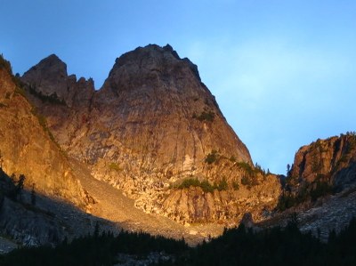
Chair Peak/Northeast Buttress
An accessible peak with 4 or 5 pitches of easy class 3-4 with breath-taking exposure. The summit has views deep into the Central Cascades. Party-caused rockfall is a definite danger to those below so consider climbing mid-week when there often are no other parties. Times: 5-8 hr trailhead to summit.
Getting There
Takes Exit 52 off of I-90, approximately 21 mi east of North Bend. At the exit, turn left on Alpental Road and drive about 2 miles to the parking lot at end of road and near Snow Lake Trailhead (3,100 ft).
APPROACH
Hike up the Snow Lake Trail ~1.5 miles. Hike the Source Lake Overlook Trail to its end at a stream next to a talus slope. Cross the stream and head up the talus, following bits of a path and staying left of brush, until catching a portion of the old trail.
Follow the old trail across the first major stream until reaching a smaller stream several hundred yards further descending from Chair's eastern basin. Ascend to the eastern basin. Ascend northwest to the upper basin under Chair Peak. Climb up (usually on snow) toward the east face of Chair Peak, then up to where the Snow Lake divide joins the Northeast Buttress.
Alternative
Hike up Snow Lake Trail ~2.5 miles. Leave the trail just before the Snow Lake divide and hike cross country, following a climber's trail or snow up the broad basin leading southwest, directly toward Chair's imposing east face. Go past the Thumb Tack and continue up the basin to the foot of the east face. Ascend the gully to the right and up to the ridge crest at the foot of the buttress.
Alternatively, from the Thumb Tack, angle sharply right and scramble up rocky heather slopes and ledges to the top of the divide. Then, hike along the north side of the divide to the base of the buttress. This route is less obvious but easier and less exposed than the gully.
ASCENT ROUTE
From the base of the buttress, climb a blocky gully that begins just down and right of the divide. The gully angles right then straightens up. From the top of the gully, continue up the blocky, low-angle face, angling left up exposed, slabby ledges toward a cluster of trees near the prow of the buttress. The initial gully/chimney requires two pitches.
At the top of Pitch 2, bear left to the buttress crest to a comfortable and generous flat area in trees. From the top of the slabby face, climb through the trees, up steep eroded and rocky heather slopes, and around the south side of the summit stack. The belay may be hard to see but is protected by bolts on the face perhaps a half rope length left of the buttress crest proper. Find the easiest route up through a steeper portion of the face to the gnarly tree. Then go up the easy loose rock to the summit.
The route involves about 400 ft of rock climbing, most exposed Class 3 and 4. Beware of rockfall hazard caused by climbers and rope drag.
DESCENT ROUTE
Scramble back down the rocky meadows to the cluster of trees at the top of the Northeast Buttress face, then alternately rappel and scramble down the route. A double-rope rappel from the trees and a bit of down-climbing to the head of the gully and another double-rope rappel will bring you to the base of the buttress
Alternative
An alternate, or emergency, the descend by contouring across the west slope of the The Tooth and scramble around to the lower basin, coming out below the Thumb Tack.
TRIP PROFILE
| SEGMENT | TIME (HR) | ELEVATION GAIN (FT) |
|---|---|---|
| Trailhead to Summit | 5-8 | 3,200 |
| Summit to Trailhead | 4-7 |
EQUIPMENT
Standard rock equipment.
NOTES
- More challenging climbing is possible by ascending directly up the buttress crest from the tree patch.
- Rockfall hazard is very serious on this climb. Take every precaution, during entire climb and descent. Rappels and rope pulling can dislodge large rocks.
Information FOr LEADERS
Permit information
As of 2017, the Snoqualmie Ranger District considers Mountaineers trips and courses to be "nominal use". Leaders should print and copy this designation letter to show Rangers they may see on the trail.
- Suitable Activities: Climbing
- Climbing Category: Basic Alpine
- Seasons: March, April, May, June, July, August, September, October
- Weather: View weather forecast
- Difficulty: Technical 3, Basic Rock Climb, Strenuous 3, Basic Experience Climb
- Elevation Gain: 3,238 ft
- 6,238 ft
-
Land Manager:
Mount Baker-Snoqualmie National Forest
Alpine Lakes Wilderness, Snoqualmie Ranger District (MBSNF)
- Parking Permit Required: Northwest Forest Pass
- Recommended Party Size: 12
- Maximum Party Size: 12
- Maximum Route/Place Capacity: 12
- Green Trails Snoqualmie Pass No. 207
- USGS Snoqualmie Pass
