
Cathedral Rock/Southwest Face
A 2-3 pitch Class 4 "knob of rock" on the eastern side of the Cascade Crest. Great views into the north central Cascades and Mount Daniel. "Very loose [rock] everywhere." according to one Mountaineer trip report. Times: 5-6 hr trailhead to summit.
Getting There
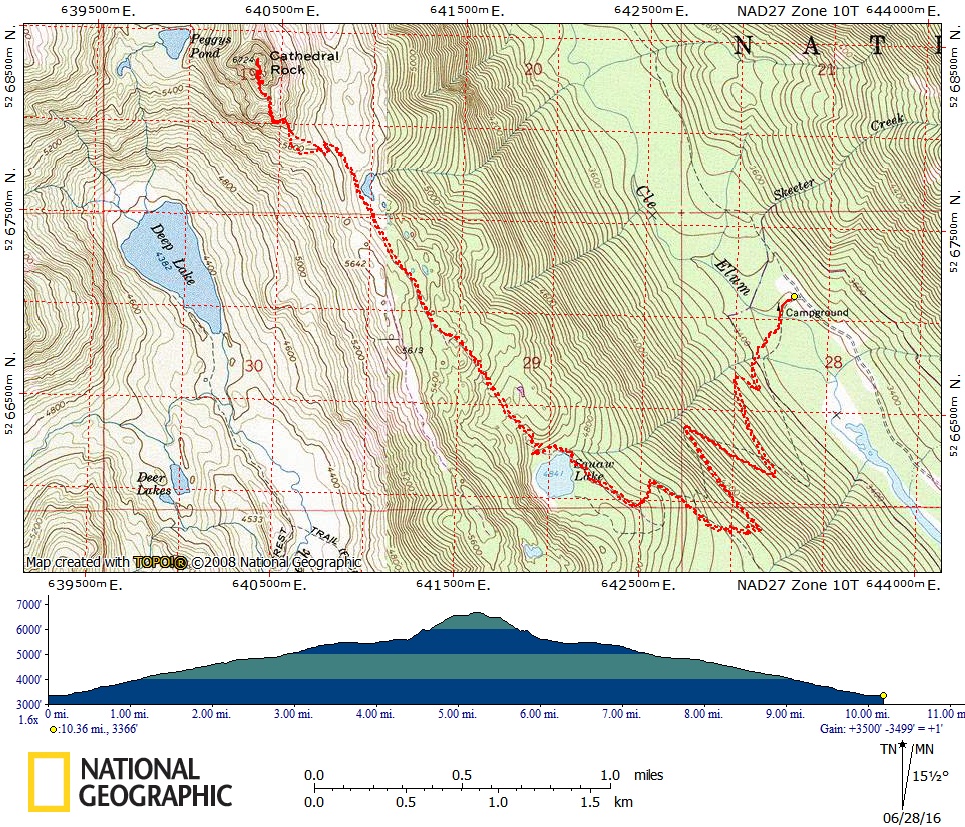
Take I-90 about 27 mi east of Snoqualmie Pass to the Roslyn exit (about 1 mi west of Cle Elum). Follow the Cle Elum River Road (State Road 903) to Salmon La Sac. A few yards past the Ranger Station, keep right on a rough dirt road (Forest Road 4330). Drive about 12 mi to the end of the road and the Cathedral Rock Trailhead (Trail No. 1345; elevation 3,350 ft).
APPROACH
Hike the Cathedral Rock trail to Squaw Lake at 2.5 mi and continue up trail to Cathedral Pass (5,550 ft). Turn left (west) onto the Pacific Crest Trail (PCT). In less than 0.5 mi, reach the junction of the PCT and Trail No. 1375, which leads to Peggy's Pond.
At this point, you'll see two climbers paths heading towards Cathedral. The left path (which looks like the wrong approach from a distance) will avoid a scree slope and offers a bit of scrambling. However, either route will work
ASCENT ROUTE
Ascend the rounded spur via a scramble gully on the right to where it meets the summit formation (6,400 ft). Climb the obvious gully on its upper left side to the left of the South Buttress, or look for detours to the left. Rockfall hazard in the gully can be serious.
One to two pitches up the Southwest Face leads to the ridge crest. Scramble to the summit but watch for loose rocks.
Alternative
Continue from Cathedral Pass to Peggy's Pond. Ascend to summit gully from ledge above Peggy's Pond.
DESCENT ROUTE
One double-rope rappel from the top of the last pitch and then down-climb the climbing route.
Alternative
Rappel to the top of the last pitch. Cross to the main east gully and scramble down to the meadows east of the peak. Traverse to Cathedral Pass.
TRIP PROFILE
| SEGMENT | TIME (HR) | ELEVATION GAIN (FT) |
|---|---|---|
| Seattle to Trailhead | 2.5 | |
| Trailhead to Summit | 5-6 | 3,400 |
| Summit to Trailhead | 4-5 |
EQUIPMENT
Standard rock equipment and large runners for rappel.
NOTES
This is generally an easy climb with excellent views. The rockfall hazard, however, is serious. In early season, when the gullies are filled with snow, the rockfall hazard should be lower. Unfortunately, vandalism occurs at the trailhead.
- Suitable Activities: Climbing
- Climbing Category: Basic Alpine
- Seasons: June, July, August, September, October
- Weather: View weather forecast
- Difficulty: Basic Rock Climb, Strenuous 1, Technical 2, Basic Experience Climb
- Elevation Gain: 3,400 ft
- 6,724 ft
-
Land Manager:
Okanogan-Wenatchee National Forests
Alpine Lakes Wilderness, Cle Elum Ranger District (OWNF)
- Parking Permit Required: Northwest Forest Pass
- Recommended Party Size: 12
- Maximum Party Size: 12
- Maximum Route/Place Capacity: 12
- Green Trails Mt Stuart No. 209
- USGS Mt Daniel
This is a list of titles that represent the variations of trips you can take at this route/place. This includes side trips, extensions and peak combinations. Not seeing a title that fits your trip? Log in and send us updates, images, or resources.
- Cathedral Rock & Mount Daniel
- Cathedral Rock/Southwest Face & Mount Daniel
- Cathedral Rock/Southwest Face & Mount Daniel/Lynch Glacier
- Cathedral Rock/Southwest Face & Mount Daniel/Daniel Glacier