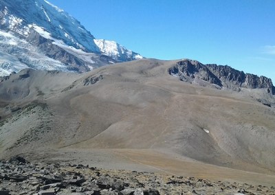
Burroughs Mountain
An easy, 4 to 7.4 mile alpine hike with ~900 ft of elevation gain around First & Second Burroughs or a strenuous, 9 mile hike with 2,900 feet of elevation gain to Third Burroughs. Hike on fragile terrain between the Winthrop and Emmons Glaciers to viewpoints with spectacular views of Columbia Crest on Mount Rainier.
This hike is in Mount Rainier National Park. The National Park Service preserves unimpaired the natural and cultural resources and values of the National Park System for the enjoyment, education, and inspiration of this and future generations. The National Park Service cooperates with partners to extend the benefits of natural and cultural resource conservation and outdoor recreation throughout this country and the world.
All participants should orient themselves to the unique geologic hazards at Mt. Rainier, an active volcano.
getting there
From SR-410, turn into Sunrise Road and enter Mount Rainier National Park at the the White River entrance. Follow Sunrise Road until it ends at the Sunrise Visitor Center (6,400 ft).
on the trail
Burroughs-sourdough-sunrise Rim loop
4 miles round trip, 840 feet of elevation gain, 7,100 ft high point, easy
An easy 4 mile loop day hike with amazing views suitable for family and adults alike. It is not unusual to see mountain goats grazing, deer, pika, marmots and wide range of flora along the way. Start at the northwest corner of the parking lot and follow the trail north beyond the rest rooms. The beginning of the hike is treeless and sunscreen and ample water are a must. Once you reach Sourdough Ridge Trail enjoy views on both sides of the trail as you approach Frozen Lake. Follow the trail to First Burroughs Mountain, the highest point on this hike. Here you can take in views of Old Desolate, a barren plateau and, by contrast, lush Berkley Park to the north, and to the south, the Emmons Glacier and the beginnings of White River. The sights and sounds of the river will follow you as you reach Shadow Lake and the Sunrise Camp. Please stay on the trail as this area has been severely damaged by off trail exploration. The remainder of the hike will pass through the subalpine meadows of Yakima Park, hopefully with abundant wildflowers in every view. The trail will gradually rise uphill until you reach your starting point, the Sunrise parking lot.
first & second burroughs
7.4 miles round trip, 900 feet of elevation gain, 7,400 ft high point, Easy
From the Sunrise parking lot start at the trailhead just to the right of the bathrooms and follow the signs to the Sourdough Ridge Trail. Follow the trail west to the five-way trail intersection just past Frozen Lake. From the intersection take the Burroughs Loop trail 0.8 miles to the summit of First Burroughs, which is basically just a flat section of the mountain. Then take the Burroughs Mountain Trail 0.6 mile to the unmarked summit of Second Burroughs, a large flat area with a wonderful PWA-style dome-shaped masonry bench.
third burroughs
9 miles round trip, 2,900 feet of elevation gain, 7,827 ft high point, Strenuous
At first glance the trail may appear to end on top of Second Burroughs, but some easy searching on the west end of the summit reveals that the trail continues down the side opposite from where you came, traverses a small valley and ascends the other side. Take the trail down via some some long lazy switchbacks to the valley until you reach the unmaintained trail that leads to Third Burroughs. The sign at the intersection mentions by name only the maintained trails, but the unmaintained Third Burroughs trail is the one that branches off to the right (west) and crosses the valley. The final section of trail to Third Burroughs crosses a large barren pumice field then ascends 800 feet, all without any protection from the sun and no views. Persevere though, because there are rewards at the top. The summit of Third Burroughs is a section of ridge about a hundred yards long with wonders to see all along its length.
notes
- On weekends during the summer tourist season the Sunrise area gets very crowded by midmorning, so an early start is recommended.
- As a variation, go through Sunrise Camp on the way between between First Burroughs and the Sunrise Visitor center. This adds about a mile each way but is approximately elevation-neutral. For example, one can hike in via Frozen Lake (as described above) and return via the less used Sunrise Camp route later in the morning when the front-country trails are more crowded.
- Suitable Activities: Day Hiking
- Seasons: July, August, September, October
- Weather: View weather forecast
- Difficulty: Easy, Strenuous
- Length: 7.4 mi
- Elevation Gain: 900 ft
- 7,400 ft
- Land Manager: Mount Rainier National Park
- Parking Permit Required: National Park Entrance Fee
- Recommended Party Size: 12
- Maximum Party Size: 12
- Maximum Route/Place Capacity: 12
- Green Trails Mount Rainier Wonderland No. 269SX
- Green Trails Mt Rainier East No. 270
This is a list of titles that represent the variations of trips you can take at this route/place. This includes side trips, extensions and peak combinations. Not seeing a title that fits your trip? Log in and send us updates, images, or resources.
- First & Second Burroughs Mountain
- Third Burroughs Mountain
- Burroughs-Sourdough-Sunrise Rim Loop
There are no resources for this route/place. Log in and send us updates, images, or resources.
