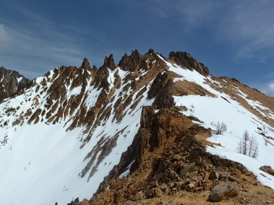
Big Snagtooth/West Ridge
Big Snagtooth is the 95th highest point in Washingtonaccording to the Bulger List. It offers a moderately strenuous off-trail approach leading to a ridge, a nice Class 2 ridge run, followed by a short technical finish. The finish includes short Class 4/low 5th class pitch and a 5.7-5.8 bouldering step onto an unprotectable Class 4 friction slab topping out on the airy summit.
Getting There
Drive SR-20 east to Washington Pass. Continue east about 3.5 miles past the hairpin turn and park on the shoulder of the highway (4320 feet).
Approach
From the road note the location of Willow Creek and look up Willow Creek Valley. Descend the embankment and enter the forest. There may or may not be way trails, game trails, markers and so on here or anywhere on this approach. When you get to Early Winters Creek, look for a safe log crossing and cross. From the opposite side of the creek, walk about 3/4 mile ascending steeply up the valley, and staying on the N side of Willow Creek. At 5,000 feet the slope will ease up. Continue SE up the valley until 5,600 feet. From here, head East into the upper basin just West of Big Snagtooth. Enter the upper basin at 7,000 feet and look for Snagtooth Ridge. Ascent to the West ridge of Big Snagtooth by staying climber's right (south). One option is to gain the ridge just left of a prominent tower demarcating the visible end of the ridge. If the slope here is not snow covered, expect horrible kitty litter and loose rock. Once on the ridge, follow it to the base of Big Snagtooth's summit block.
Ascent Route
At the base of the summit block climb the steep, blocky weakness. This pitch is short and will likely require 2-3 pieces. Set up a fixed line or belay followers then scramble up and climber's left to the base of the final pitch. This pitch is unprotectable and has a 5.7-5.8 boulder-move start which then immediately eases to a class 4/low 5th friction slab to the rappel anchor. Set up a fixed line here for followers. Some leaders may ask for a spot to get up the first 5 feet.
Descent Route
Rappel from just below the summit back to the base of the boulder move then scramble back to the first pitch, locate the rappel anchor and rappel. Both rappels can be done on a 30m rope.
Trip Profile
| SEGMENT | TIME(HR) | ELEVATION GAIN (FT) |
|---|---|---|
| Seattle to Trailhead | 3.5 | |
| Trailhead to Summit Block | 3-4 | 3800 |
| Summit Block to Summit | 2 | 100 |
| Summit to Trailhead | 3-4 |
Equipment
Standard rock equipment including a very light alpine rack (2 small cams and 2 medium cams recommended).
Notes
An ice axe is needed for the approach in early season.
- Suitable Activities: Climbing
- Climbing Category: Basic Alpine
- Seasons: May, June, July, August, September, October
- Weather: View weather forecast
- Difficulty: Basic Rock Climb
- Length: 7.5 mi
- Elevation Gain: 4,500 ft
- 8,330 ft
-
Land Manager:
Okanogan-Wenatchee National Forests
Methow Valley Ranger District (OWNF)
- Parking Permit Required: None
- Recommended Party Size: 12
- Maximum Party Size: 12
- Maximum Route/Place Capacity: 12
- USGS Washington Pass
- USGS Silver Star Mtn
- Trails Illustrated North Cascades National Park
There are no resources for this route/place. Log in and send us updates, images, or resources.
