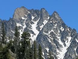
Argonaut Peak/Northwest Arête
A Grade II, Class 5.6 rock climb in the Alpine Lakes Wilderness.
getting there
For more popular Mountaineer Creek approach, turn onto Icicle Creek Road from US 2 in Leavenworth and drive 8.6 miles to Eightmile Road. Turn left and drive 3.5 miles to road's end and the Stuart Lake Trailhead (3,600 ft).
Approach
Hike the Stuart Lake Trail about 3 miles to where Mountaineer Creek enters. Past the stream junction at the first minor switchback after a meadow, leave Stuart Lake Trail (~4,640 ft), cross the stream flowing from Stuart Lake. Then locate a faint path heading up the west side of Mountaineer Creek. Ascend along Mountaineer Creek to where the valley forks at 4,800 ft (3-4 hours) and possible, but not recommended campsites. Follow the east-most fork up towards the Argonaut-Colchuck Col. There are good bivy sites at 6,400 ft in Argonaut’s north basin.
Alternate approaches to Argonaut-Colchuck Col are (1) Colchuck Lake to Colchuck Col, then skirting Colchuck Peak’s south flanks and (2) Ingalls Creek Trail to Porcupine Creek then up to the col.
Ascent
From Argonaut’s north basin the climb to snow finger leading up to the Northwest Buttress (visible to the right in the picture, Cascade Alpine Guide Vol. 1). Ascend to the top of the gully, a small col, and the start of 6 to 8 pitches of rock climbing. Straight forward route finding leads up blocky, generally solid but not sustained Class 4 to 5.6 climbing.
DESCENT ROUTE
From the east ridge, descend to Argonaut-Colchuck Col in four rappels. Descend retrace the ascent route.
TRIP PROFILE
| SEGMENT | TIME (HR) | ELEVATION GAIN/Loss (FT) | Mileage |
|---|---|---|---|
| Trailhead to Camp | 4-8 | + 3,000 | |
| Camp to Summit | 7-9 | + 2,150 | |
| Summit to Trailhead | ? | - 5150 |
NOTES
- Note that the route is listed in Cascade Alpine Guide Vol. 1 as a West Ridge variation without detailed route description. Do NOT follow approach directions for West Ridge.
- Camping at Mountaineer Creek Fork camp, may require 10 to 12 hours to reach the summit.
- Two days are recommended.
- The snow finger may be hard and intimidating in late season.
- Permits are required to camp on the north side of Stuart Ridge.
- Suitable Activities: Climbing
- Climbing Category: Intermediate Alpine
- Seasons: May, June, July, August, September, October
- Weather: View weather forecast
- Difficulty: Intermediate Rock Climb
- Length: 20.0 mi
- Elevation Gain: 4,853 ft
- 8,453 ft
-
Land Manager:
Okanogan-Wenatchee National Forests
Alpine Lakes Wilderness, Wenatchee River Ranger District (OWNF)
- Parking Permit Required: Northwest Forest Pass
- Recommended Party Size: 12
- Maximum Party Size: 12
- Maximum Route/Place Capacity: 12
- Green Trails Mt Stuart No. 209
- Green Trails Alpine Lakes East (Stuart Range) No. 208SX
- USGS Enchantment Lakes
- Green Trails Enchantment Lakes No. 209S
- USGS Mount Stuart
There are no resources for this route/place. Log in and send us updates, images, or resources.
