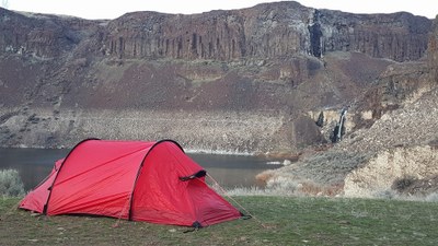
Ancient Lake
A desert area in eastern Washington that offers hiking, backpacking, and bikepacking option from 5 to 20 miles and 200 to 1,500 feet of elevation gain. Travel through desert, past basalt walls, and around the lakes, at the end of which is a waterfall, a rare feature in a desert. Enjoy wildflowers and interesting geology just to the east of the Columbia River near Vantage along the way.
getting there
Take Exit 149 off of I-5, turn left and drive 5.6 miles north on SR-281 toward Quincy. Turn left onto White Trail Road, drive 7.8 miles, turn left onto Road 9-NW. Drive 5.9 miles as the road descends steeply down to Babcock Bench at the road's end. Avoid parking in a way that blocks the gate whcih provides access to a private driveway.
on the trail
Ancient Lake
4-5 miles round trip with 200 feet of elevation gain, 860 ft high point
Hike the dirt road 0.7 mile to the trailhead and turn left onto the trail to Ancient Lakes.
Dusty Lake
6 miles round trip with 400 feet of elevation gain, 1,000 ft high point
Hike the dirt road 0.7 mile to the trailhead and turn right to stay on the road and continue to Dusty Lake.
Bikepacking
The lower trailhead access is best for bikes because it avoids steep loose rock cliffs. The lower area offers a network of easy to intermediate single-track and double-track trails. Trails are rocky to sandy with options for more challenging routes if desired. Visit the Evergreen Mountain Bike Alliance's "Ancient Lakes" web page for more info.
Camping
Good overnight camping options are by the three Ancient Lakes and by Dusty Lake.
Water
Carry all your own water. There are NO options for filtering drinking water, because water from the lakes is contaminated by agricultural run-off. To minimize the distance water must be carried, camp by the three Ancient Lakes.
notes
- More information and inspiration in this Seattle P-I article by Karen Sykes.
- Trips are best done in early spring or fall when temperatures are cool and rattlesnakes and tube punching goat heads are less of an issue.
Information for Leaders
Scheduling & Permits
- This route allows multiple bookings. Please check scheduled trips listed below in the "Activities" tab to see if there is another group already booked on the same day. Leaders are expected to contact the leader(s) of existing trips to ensure there are no concerns or conflicts, according to The Mountaineers Outdoor Ethics Policy. Please review our Group Size & Multiple Bookings page for guidance.
- Suitable Activities: Backpacking, Bikepacking, Day Hiking
- Seasons: Year-round
- Weather: View weather forecast
- Difficulty: *Varies*, Bikepacking MTB I
- Length: 5.0 mi
- Elevation Gain: 200 ft
- 860 ft
- Land Manager: Ancient Lake Water Access
- Parking Permit Required: Discover Pass
- Recommended Party Size: 12
- Maximum Party Size: 12
- Maximum Route/Place Capacity: 12
- WA DNR Moses Lake
This is a list of titles that represent the variations of trips you can take at this route/place. This includes side trips, extensions and peak combinations. Not seeing a title that fits your trip? Log in and send us updates, images, or resources.
- Dusty Lake
- Ancient & Dusty Lakes
- Ancient Lakes and the Columbia River
There are no resources for this route/place. Log in and send us updates, images, or resources.
