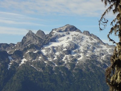
Bedal Peak
A good one day rock scramble that has a little bit of everything. River crossing, navigation in thick forests, snow travel, and a short Class 2-3 rock scramble. All topped off with one of the best summit views of any peak on the mountain loop highway.
getting there
Cougar Creek
Drive the Mountain Loop Highway, to 17 miles south of Darrington and turn left onto the North Fork Sauk River Road. (Note: If you reach Bedal campground before turning onto this road you have gone 0.25 mile too far). Drive 4.5 miles to a pull out just past Garnet Creek (1,900 ft).
Merry Brook
Drive the Mountain Loop Highway to 18.25 miles south of Darrington (~1 mile south of the Bedal Campground) or 7 miles north of Barlow Pass, and turn left onto Forest Road 4096. Drive 2 miles to the trailhead (2,800ft).
Approach & Ascent
Cougar Creek
Follow a way trail and flagging 0.5 mile to the North Fork Sauk River crossing. Find the flagged climbers trail on the other side and follow it to Cougar Creek at ~1,900 ft. On the west side of the creek find a faint trail heading southeast up the right side of the creek. Follow this as it fades in and out eventually aiming for the upper slopes of the sub-ridge to the south of Cougar Lake. Continue up into the open basin to the northwest of Bedal Peak.
Below the summit cliffs head southeast towards a low point in the ridge. Cross approximately 30 feet of solid and easy, but exposed Class 2-3 slabs with bad run out and gain the summit ridge. This ascent is the crux move of the scramble and can be very slippery when wet. The ascent can be readily protected with a hand line. Continue the last 250 feet of elevation gain to the summit on an easy and distinct climbers trail.
- The river on this approach is impassible in high water unless a log jam can be found to cross on and is usually best done in late July or later.
Merry Brook and northwest ridge
Travel on the boot path that starts northeast of road. It is aggressively steep and has many deadfalls to climb under and over. It turns south on less steep terrain above and just west of Nels Lake. Ascend four boulder fields and then reach meadows at a point marked with a unique & distinctive cluster of boulders. Approximately 50 feet above the boulders turn sharply east to cross a V-notch and ascend the opposite side on mossy ramp (it's not visible from below). Travel to the east of a large buttress, and then turn south to reach mixed rock & snow at ~5,200 ft. Ascend the snowfield adjacent to the pinnacles on ridge. The summit is the last of these pinnacles and is easiest reached by crossing the snowfield southeast to gain the east ridge, and then an easy walkup west to summit.
- There are many pinnacles on ridge so in low visibility it can be hard to tell when you are at the final, correct one.
- When descending thru forest, boot path is much less visibly obvious than the ascent.
- This approach is a bit less technical than the Cougar Creek approach.
notes
- In late summer and fall before first frosts this route can have a number of Yellow Jacket nests.
- Suitable Activities: Scrambling
- Seasons: July, August, September, October
- Weather: View weather forecast
- Difficulty: Strenuous 5, Technical 4
- Length: 7.5 mi
- Elevation Gain: 4,500 ft
- 6,554 ft
-
Land Manager:
Mount Baker-Snoqualmie National Forest
Darrington Ranger District (MBSNF)
- Parking Permit Required: Northwest Forest Pass
- Recommended Party Size: 12
- Maximum Party Size: 12
- Maximum Route/Place Capacity: 12
- Green Trails Sloan Peak No. 111
- USGS Sloan Peak
This is a list of titles that represent the variations of trips you can take at this route/place. This includes side trips, extensions and peak combinations. Not seeing a title that fits your trip? Log in and send us updates, images, or resources.
- Bedal Peak via Merry Brook
- Bedal Peak via Cougar Creek
There are no resources for this route/place. Log in and send us updates, images, or resources.
