Trip
Day Hike - Yellow Aster Butte
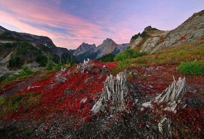
Often mentioned as "the favorite" for PNW hikers, Yellow Aster Butte is 7.5 miles roundtrip with ~3,000 ft elevation gain. Apparently has stunning fall colors, with views into Canada. ***Average pace of 2.5 mph: ~2 mph uphill and ~3 mph downhill.*** RESCHEDULED TO 10/20 DUE TO SUB-OPTIMAL WEATHER.
- Fri, Oct 20, 2023
- Foothills Hiking Committee
- Day Hiking
- Adults
- Moderate/Strenuous
- Challenging
- Mileage: 7.61 mi
- Elevation Gain: 2,458 ft
- High Point Elevation: 6,150 ft
- Pace: avg 2.5 mph
- 3 (8 capacity)
- FULL (2 capacity)
- Cancellation & Refund Policy
PLEASE ONLY REGISTER FOR THIS HIKE IF YOU ARE SERIOUS ABOUT EITHER GETTING UP EARLY TO MAKE IT TO THE TRAILHEAD ON-TIME, OR PLAN ON STAYING OVERNIGHT NEARBY ON THURS.
Meet at 8:45 am at the Tomyhoi Lake/Yellow Aster Butte Trailhead ready to hike. Following introductions, description of route and current trail conditions, plan to start hiking a few minutes before 9:00 am. Vault toilet at trailhead. Northwest Forest pass required.
Directions: From the Glacier Public Service Center on Highway 542 (34 miles east of I-5), drive east for about 12 miles, then turn left onto Twin Lakes Road (FR 3065). Keep a sharp eye out for the WSDOT Shuksan maintenance facility; the road is located at the east end this facility. Proceed 4.5 miles on Forest Service Road 3065, then reach the Tomyhoi Lake/Yellow Aster Butte Trailhead and parking area.
Yellow Aster Butte is one of the most popular trails in the North Cascades. The trail with a steep ascent which gains nearly 1500 feet of elevation in just under a mile and a half. Further on are several switchbacks and a forest until we'll emerge into a meadow. Apparently the hillsides are vivid in orange, reds and yellows in the fall. Clear skies permitting, we should have stunning views of Mounts Baker and Larrabee, the western section of the High Divide, and, in Canada, the Border Peaks.
Since this is a day hike and I'm coming from the Eastside, we'll need to keep a brisk pace: ~2.0 mph uphill and ~2.5-3.0 mph downhill depending on steepness. Of course, we'll periodically have brief stops along the way for clothing adjustments, as well as 20-30 min in the meadow to enjoy a snack, the views and fall colors.
It is important for all registrants to know their pacing...how comfortable are you hiking uphill at 2 mph with a couple of brief stops? Please contact the leader before registering if you have not recently done a hike of similar mileage, or have any doubt about your fitness and stamina to keep up. At the same time, please don't be "scared" about joining if you will have done several hikes of similar length, elevation and speed before Oct 20. We hike as a group.
Gaia route: https://www.gaiagps.com/map/?loc=15.0/-121.6881/48.9481&pubLink=TFOtYKX1sLMXMTQPEQSs7UZg&trackId=6f56f8ae-3125-46de-9325-dc7e48e9b589
Leader reserves the right to cancel registrants off the roster for any reason, particularly non-responsiveness to e-mail communication. Full details will be emailed arounf Oct 17. In the interim please contact the leader with any questions: BMPeacock@aol.com.
Yellow Aster Butte
-
Green Trails Mount Baker Wilderness Climbing No. 13SX
Green Trails Mt Shuksan No. 14
USGS Mount Larrabee - See full route/place details.
Required Equipment
- Navigation
- Headlamp
- Sun protection
- First aid
- Knife
- Fire
- Shelter
- Extra food
- Extra water
- Extra clothes
- Poles and sturdy boots with ankle support recommended
