Trip
Basic Snowshoe - Pipe Creek Snowshoe
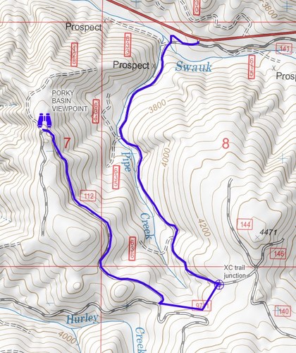
Forecast indicates fresh snowfall. This is an exploratory trip to less frequented snowshoe trails. The route is mainly through the forest with occasional views. Almost all on abandoned FS roads at a moderate gradient but may require trailbreaking and navigation. (see embedded map). READ LEADER'S NOTES BEFORE REGISTERING. TO JOIN, YOU MUST HAVE A COMPLETED BADGE - SORRY NO STUDENTS.
- Sat, Mar 2, 2024
- Foothills Snowshoeing Committee
- Snowshoeing
- Basic
- Adults
- Moderate
- Moderate
- Mileage: 7.0 mi
- Elevation Gain: 900 ft
- High Point Elevation: 4,200 ft
- Pace: 1.5-2.0 mph avg moving pace
- 6 (6 capacity)
- 2 (2 capacity)
- Cancellation & Refund Policy
- 7:30am North Bend in front of now-closed Chase Bank. Do NOT proceed to Pipe Creek. In North Bend, we'll assess driving conditions along the route before proceeding. If the driving route is unsafe, group will go to an alternative destination.
- Pipe Crk SnoPark is located ~1.5 mi west of Blewett Pass and ~25 mi east of Cle Elum. From Seattle, ~100 miles (for comparison: from Seattle, Stevens Pass is ~85 miles).
- Weather - from NWS
- Avalanche forecast (East Slopes Central) - https://nwac.us/avalanche-forecast/#/east-slopes-central
- Blewett Pass road conditions (webcam) - https://wsdot.com/travel/real-time/mountainpasses/Blewett
- SnoPark Pass for ungroomed trails is required. Trip Leader has a Pass and can drive.
- Portapotty is located in the SnoPark
- We'll follow FR 9700-140 to reach a junction that can take us west to Porky Basin viewpoint. We may also visit Diamond View loop. If the day is clear, there are views of Diamond Head near Blewett Pass and/or the Stewart Range to the north.
- Once we have departed from FR9700-140, it is not a frequently used snowshoe route, we will use navigation to find our route. You must be comfortable with this approach. With navigation tools, Forest Service roads are pretty easy to find and follow. Here's general map showing all the routes (click here).
- Our turnaround point will be determined by getting back to our vehicles with a safety margin with respect to driving conditions & available daylight.
- Join this trip ONLY if you are comfortable with the exploratory nature of this trip, off-trail navigation and potential for trailbreaking. I use a route map as a general guide to know where we are in the environment, but not as an exact route to follow. In the winter, route-finding means locating a safe and an interesting path to a destination. You MUST be comfortable with the process of navigation and group discussions about which way to go ... if this makes you anxious or impatient, this is NOT the trip for you.
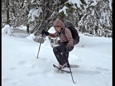
- The headline picture is of trailbreaking at this location in January 2024. The snow was untracked and deep. No guarantees for this trip, but it could happen 😍❄️
- Cancellation will occur if there are hazardous weather or road conditions, if it's raining or if there's inadequate snow.

Image shows route from Pipe Creek to Porky Basin viewpoint with additional opportunities for exploring other FS roads not shown on the map.
Route/Place
Roster
Required Equipment
Required Equipment
- The Ten Essentials
- Snowshoes
- Poles
Trip Reports
