Trip
Backpack - Entiat River Meadows & High Country
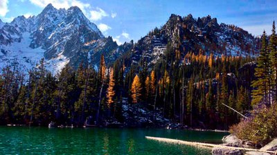
This very strenuous backpack of 47 miles and 10,400’ of climbing will travel to some of the scenic highlights of the Entiat River Valley, including Ice Lakes, Entiat Meadows, Larch Lake and Cow Creek Meadows, and rated 9/10 for scenery by guidebook author Douglas Lorain. Leader permission required.
- Mon, Aug 12, 2024 — Fri, Aug 16, 2024
- Foothills Backpacking Committee
- Backpacking
- Adults
- Very Strenuous
- Challenging
- Mileage: 47.0 mi
- Elevation Gain: 10,400 ft
- Pace: 2.0 mph
- 1 (5 capacity)
- Cancellation & Refund Policy
10:00 AM, August 12, 2024, Entiat River Trailhead, which is about a 4 hour drive from Seattle.
According to WTA: The Entiat River Road (FR 51) is just south of the town of Entiat on SR 2/US-97 N. The trailhead is a little over 38 miles up the valley a short distance past where the road (FR 5100) turns to gravel at the Cottonwood campground. There is a vault toilet at the campground junction and at the trailhead.
The road to the trailhead is paved almost to the end, but has 3 water crossings which should not be a problem based on a WTA report from a Mountaineers trip in late June 2022.
EV access: Depending on the electric car, the trailhead will be accessible by an EV. Entiat, Washington, which is 78 roundtrip miles from the trailhead, has Tesla high-speed chargers. Entiat has (free!) level 2, 7 kw, J-1772 chargers at the Entiat Park and Ride There are also may be level 2 EV charging at the Entiat City Park.
The tentative plan:
Day 1: Drive to trailhead, hike along the Entiat River Trail and then a short distance to camp on the Ice Creek Trail. 9.0 miles, 2,000’ gain.
Day 2: Day hike steeply from Ice Creek Camp to Upper Ice Lake, described by guidebook author Craig Romano as “tucked in a glacially scoured basin sprinkled with pumice and dotted with larches high in the stark, grey, towering Entiat Mountains.” 9.7 miles, 3,200’ gain.
Day 3: Move camp to Entiat Meadow, described by guidebook author Douglas Lorain as “one of the most beautiful mountain meadows in the state.” 7.3 miles, 1,500’ gain. Based on conditions, we may hike to Entiat Meadow via Cool Creek Pass, which would be 6.2 miles with 3,200’ of gain.
Day 4: Move camp to Upper Larch Lake. 12.8 miles, 2,300’ gain.
Day 5: Hike back to trailhead, via Garland Peak Trail and Cow Creek Trail, passing Cow Creek Meadows and Myrtle Lake. 8.2 miles, 1,400’ gain.
Here is a link to the tentative route in Caltopo.
Portions of the route go through areas affected by forest fires. (Clicking the Fire History tab in Caltopo, shows the extent of past fires.) Also, the first few miles of the Entiat River trail are open to motorcycle traffic which should be minimized by our midweek dates. We will ford some unbridged rivers, though the water level will be reduced by our August date.
Leader permission: Leader permission is required, which you can obtain by sending an email to the leader. When you request leader permission, please accompany your request with the answers to the questions available at this link. You can download these questions, type in your responses below each question, save and email to me; or copy and paste into an email and put your responses there.
Spots will not be allocated first-come-first-served; the leader will collect permission requests for 2 weeks after the trip opens and grant spots to the most qualified after that period ends.
Weather: I expect low overnight temperatures will be in the 30s. You should check the current weather report shortly before departure. Rain should be expected, and you should bring a raincoat, rain pants, and pack cover and clothes that will keep you warm when wet (no cotton!). The trip is subject to change or cancellation if the predicted weather is unusually poor or there is substantial smoke or nearby fires.
Maps: Green Trails Holden 113, Lucerne 114, North Cascades/Lake Chelan 114SX
Guide books: Backpacking Washington, Craig Romano (Ice Lakes); Backpacking Washington, Douglas Lorain
Conditioning: This trip requires excellent conditioning. We will average about 2 mph on the trail, including breaks. You should be able to climb Mt. Si with a full backpack in 3 hours or less, and be able to repeat the climb the next day.
Full vaccination and booster are required.
Gear notes:
- There are no reliable bear hangs in this area, so Ursack or bear canister are required.
- You should bring some method of water purification.
- Bugs are certainly possible; bring bug repellent.
- Shoes suitable for river fording; Crocs ok
Additional gear requirements listed in the trip application.
Entiat River Meadows & High Country
-
Green Trails Lucerne No. 114
Green Trails Holden No. 113 - See full route/place details.
Required Equipment
The Ten Essentials plus overnight gear which may include:
- Tent with footprint/ground tarp
- Stove and fuel
- Sleeping bag
- Sleeping pad
- Water filter
- Cooking pot/pan with plate and utensils
- Toilet paper and shovel or blue bag to deal with waste
- There are no reliable bear hangs in this area, so Ursack or bear canister are required.
- You should bring some method of water purification.
- Bugs are certainly possible; bring bug repellent.
- Shoes suitable for river fording; Crocs ok
- Additional gear requirements listed in the trip application.
