Trip
Alpine Scramble - Baldy & Tyler Peak
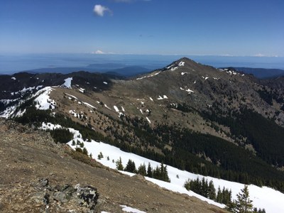
A gorgeous (but strenuous ;) early season ridge run of ~5000’ gain and ~11 miles total. Beautiful flowers and majestic views of San Juan Islands and NE Olympics.
- Sat, Jun 8, 2019
- Seattle Alpine Scrambling
- Scrambling
- Adults
- Strenuous, Rock Scramble, Technical 3, Strenuous 5
- Challenging
- Mileage: 11.0 mi
- Elevation Gain: 5,000 ft
- High Point Elevation: 6,827 ft
- 1 (7 capacity)
- Cancellation & Refund Policy
Various P&Rs to accommodate attendees, then the 6:10AM Edmonds/Kingston ferry to rendezvous at the Louella Road/Highway 101 intersection (near the Sequim Bay State Park) at 7:30AM for our final car caravan to the Upper Dungeness River trailhead.
Only for folks with recent/frequent scrambles of a similar strenuousness. We will be doing a counter-clockwise loop that starts (and ends) at the Upper Dungeness River trailhead. From the cars we will backtrack a bit along the road until we cross the bridge over Mueller Creek (may be substantial flow). From there we will scramble/ascend ~600’ on a forested ridgelet to reach the Mueller Creek trail/parking area. After ascending Tyler Peak by this trail, we will run the ridge to Baldy, then descend SE from Point 6537 on the Upper Maynard Burn Trail. The day will end by following the Lower Maynard Burn Trail and Royal Basin Trail to reach the cars. Photos from prior trips can be seen here.
Baldy & Tyler Peak
-
Green Trails Olympic Mountains East No. 168S
Custom Correct Buckhorn Wilderness
Custom Correct Gray Wolf - Dosewallips
USGS Mt Deception
USGS Tyler Peak - See full route/place details.
Required Equipment
- The Ten Essentials
- Helmet
- Mountaineering Boots
- Ice Axe
