Field trip: GoHike: Beginner Hiking Course
March GoHike Pacing Hikes: 2 to 4 miles, 0 to 750 feet of elevation gain - Sequalitchew Creek
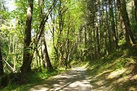
Enjoy this gentle historical hike through a forested canyon with lunch along Puget Sound by the former railroad pier where dynamite from the DuPont factory was loaded onto ships. It is intended to help you and the GoHike team determine what pace and challenge level you want to start with in the series.
- Sat, Mar 20, 2021
- Foothills Hiking Committee
- Day Hiking
- Adults
- Easy
- For Beginners (Getting Started Series)
- Mileage: 3.0 mi
- Elevation Gain: 218 ft
- High Point Elevation: 218 ft
- Pace: 1-1.5 mph
- 8 (7 capacity)
- Cancellation & Refund Policy
Meet at 11AM at the DuPont City Hall parking lot. Google map directions https://goo.gl/maps/WN1DBCu4izzzuJ4E9.
Carpooling is not recommended at this time due to the risk of Covid-19.
No parking pass is required at the trailhead parking lot. There is a portapotty available there, but not elsewhere on the hike.
We will hike a 1.5 mile wide, well-maintained trail, part asphalt and part gravel, that gently declines through the scenic Sequalitchew Creek Canyon. Near the end it passes through a railroad underpass just before reaching the shore of Puget Sound, our lunch spot and turnaround point. We will stop by the remains of a railroad pier from which dynamite manufactured by the former nearby DuPont factory was loaded onto ships. The first buildings in DuPont were built in the 1830s, so it was one of the oldest towns in the Puget Sound area. The 218 feet gain is all on the return hike. Bathroom breaks can be taken during the lunch break behind the nearby bushes.
Required Equipment
Wear footwear suitable for walking on asphalt, gravel and beach sand.
Clothing should all be non-cotton and able to be layered.
Rain gear, including a pack cover, should be available if needed.
At lunch time, you will probably be sitting on a log, so a sit pad will make that more comfortable if the log is wet.
Craig Romano's Urban Trails Tacoma book on pages 89-93 describes more about the history of the area and has a good map of the hiking route on page 90.
