Sunrise Ridge (Olympics)
An easy to intermediate 5 mile snowshoe delivers endless stunning snow sculptures from the winds torturing Hurricane Ridge while testing basic and some intermediate snow travel skills.
Getting there
Drive US 101 to Port Angeles and then 17 miles up Hurricane Ridge Road (aka Heart o' the Hills Parkway) to the Hurricane Ridge Visitor Center.
snowshoe route
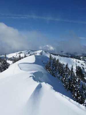
Begin at the ski trailer end of Hurricane Ridge Parking Lot and ascend about 275 feet up the ski slope to the rope tow head. There is plenty of room for skiers and snowshoers when the rope is operating. From the tow head, it's a short distance on the ridgeline until you reach Sunrise Point, a lookout at 5,500 ft. From Sunrise Point quickly drop down a steep slope to the saddle between Sunrise Point and the remainder of Sunrise Ridge. Slowly ascending Sunrise Ridge along the ridgecrest, endless views of the sculpted snow greet us displaying a show confined within the valley between Sunrise, Unicorn Peak, and the Hurricane Hill ridgeline. The trail mildly undulates the ridge crest until you are high above the saddle between Sunrise Ridge and the trail around or up Mount Angeles. Usually this is the great stopping point unless the snowpack is quite stable.
The cascade of cornices overhanging the saddle from the Sunrise side of the trail make for solid technical snowpack evaluation and travel skills and should be attempted with caution and burial recovery equipment. After making this saddle, the western approach to Mount Angeles can be had on the left and the trail to Klahhane Ridge heads counter-clockwise about Mount Angeles. Somewhere along the way, the Switchback Trail to the road may be encountered.
notes
- The road to Hurricane Ridge can be closed in the mornings for snow removal in winter. Check current snow and road conditions before leaving town. The Twitter Feed “Hurricane Ridge NPS” provides road opening status. Keep your cell phone on to receive Olympic National Park provided Emergency Weather Alerts via the Amber Alert feature of smart phones.
- All vehicles are required to carry tire chains when traveling above the Heart O' the Hills entrance station during the winter season. This requirement applies to all vehicles (including four-wheel-drive), regardless of tire type or weather conditions.
- Conditions can go to blinding white out in minutes via fast moving cloud cover or driving wind.
- Walking the ridgeline has a distinct advantage and disadvantage: the good side is that you can see any cloud cover (aka whiteout) moving towards you from the valleys below and the bad side being caught in a whiteout on a ridge crest can be quite dangerous if you continue moving when you can't see (look at some of the fall lines in the picture above).
- Suitable Activities: Backcountry Skiing, Snowshoeing
- Snowshoeing Category: Basic
- Seasons: January, February, March, December
- Weather: View weather forecast
- View avalanche forecast.
- Difficulty: Easy, Easy/Moderate
- Length: 5.1 mi
- Elevation Gain: 650 ft
- 5,500 ft
- Land Manager: Olympic National Park
- Parking Permit Required: National Park Entrance Fee
- Recommended Party Size: 12
- Maximum Party Size: 12
- Maximum Route/Place Capacity: 12
- Green Trails Hurricane Ridge/Elwha North No. 134S
- Custom Correct Hurricane Ridge
- USGS Mt Angeles
This is a list of titles that represent the variations of trips you can take at this route/place. This includes side trips, extensions and peak combinations. Not seeing a title that fits your trip? Log in and send us updates, images, or resources.
- Sunrise Ridge (Olympics)
- Sunrise Ridge
There are no resources for this route/place. Log in and send us updates, images, or resources.
