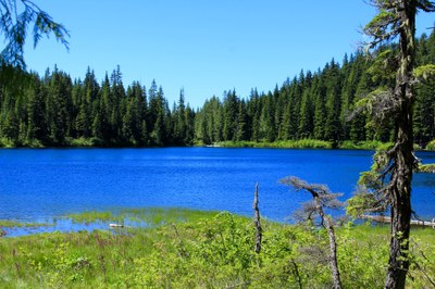
Talapus Lake Trail
Hike ascending through forests to two secluded lakes near Snoqualmie Pass. In winter, a strenuous snowshoe routes leads to Ollalie Lake and Pratt Vista. Hearty hikers can opt for an 18-mile trip from Talapus Lake to Mason Lake and out the Ira Spring Trail or plan a backpacking trip to visit and enjoy the many lakes in the area.
getting there
summer
Take Exit 45 off of I-90 and turn north onto Forest Road 9030. In 0.8 mile at the junction with Forest Road 9031, stay on Forest Road 9030 by turning sharply right. Continue 2.4 miles to the Talapus Lake Trailhead (2,800 ft).
winter
Take Exit 45 off of I-90 and turn north onto Forest Road 9030. Often the road is blocked by snow not far from the freeway. It's best to park here unless the road is snow free to its intersection with Forest Road 9031.
on the trail
Talapus & Ollalie lakes
4 miles round trip with 1,220 feet of elevation gain
Hike 1.7 miles to Talapus Lake (3,250 ft) and another 07 miles to a trail junction (3,700 ft). Go straight and descend 0.7 miles to Olallie Lake (3,800 ft).
Talapus Lake to Mason Lake and Ira Spring Trail
18 miles with 4,600 feet of elevation gain
Climb up to Talapus lake through second growth forest and continue up in switchbacks traversing Ollalie, Pratt and Talapus takes, descending into Island and Mason Lakes. Then continue on the Ira Spring trail back to the trailhead traversing Bandera Mountain. Cars must be placed at the Talapus Lake and Ira Spring Trail trailheads, because the trailheads are about 5 miles apart. The hike features good fall color, and forest and streamside flowers as well as subalpine meadows on the side of Bandera Mountain.
Talapus, Olallie, Island & Pratt Lakes Loop
20-mile loop, 6,000 feet of elevation gain
Suggested Itinerary: Day 1 - Hike to the north side of Olallie Lake and then go up tpo Island Lake via an informal and steep side trail. Day 2 - Hike to Pratt Lake and set up camp there. Then explore the Pratt Connector Trail. This trail may have some obstacles and bushwhacking. Day 3 - Hike back to the trailhead via Olallie Lake.
Talapus, Ollalie, Rainbow & Island Lakes
10.6 miles round trip, 1,800 feet of elevation gain
Hike from the trailhead to Rainbow and Island Lakes passing Talapus and Olallie Lakes on the way.
Snowshoe Route
Pratt Vista
Pratt Vista is the ridge due north of Olallie Lake between West Granite and Pratt Mountains. Follow Forest Road 9030 9030 to the Talapus Lake Trailhead (2,800 ft). Follow the route of the summer trail if you can. If you loose the trail, it is better to stay higher than lower to avoid steep terrain down near the creek. When you reach Talapus Lake, continue heading north. At ~3,600 ft traverse east to Ollalie Creek and cross it where you can (this may be ver near the Ollalie Lake) and continue to 3,800 ft on the southeast side of Ollalie Lake. Follow the route of the summer trail as it heads north around Ollalie Lake. At ~4,000 ft and northeast of the lake, the summer trail bends to the left. Leave the trail here and ascend north to the ridge. If avalanche conditions are “considerable” or higher, keep to the left to stay more in the trees, otherwise, keep right to have more open terrain. Upon reaching the ridge, enjoy the view of Pratt to the west, Kaleetan to the north, and Tusk O’ Granite to the east. Follow the ridge west then southwest to just past the lowest spot on the ridge at 4,150 ft. Turn southeast and descend the forested slopes to the outlet of Ollalie Lake and retrace your route to your car.
Information for leaders
Scheduling & Permits
- As of 2017, the Snoqualmie Ranger District considers Mountaineers trips and courses to be "nominal use". Leaders should print and copy this designation letter or carry a digital copy on their phone to show rangers they may see on trail.
- This route allows multiple bookings. Please check scheduled trips listed below in the "Activities" tab to see if there is another group already booked on the same day. Leaders are expected to contact the leader(s) of existing trips to ensure there are no concerns or conflicts, according to The Mountaineers Outdoor Ethics Policy. Please review our Group Size & Multiple Bookings page for guidance.
- Suitable Activities: Backpacking, Day Hiking, Snowshoeing
- Seasons: June, July, August, September, October
- Weather: View weather forecast
- Difficulty: Moderate, Moderate/Strenuous, Strenuous
- Length: 4.0 mi
- Elevation Gain: 1,220 ft
- 3,780 ft
-
Land Manager:
Mount Baker-Snoqualmie National Forest
Alpine Lakes Wilderness
- Parking Permit Required: Northwest Forest Pass
- Recommended Party Size: 12
- Maximum Party Size: 12
- Maximum Route/Place Capacity: 12
- Green Trails Snoqualmie Pass Gateway No. 207S
- Green Trails Bandera No. 206
This is a list of titles that represent the variations of trips you can take at this route/place. This includes side trips, extensions and peak combinations. Not seeing a title that fits your trip? Log in and send us updates, images, or resources.
- Talapus Lake
- Olallie Lake
- Talapus & Olallie Lakes
- Pratt Vista
- Talapus Lake to Mason Lake and Ira Spring Trail
- Talapus, Olallie, Island & Pratt Lakes Loop
- Talapus, Ollalie, & Pratt Lakes
- Talapus, Ollalie, Rainbow & Island Lakes
There are no resources for this route/place. Log in and send us updates, images, or resources.
