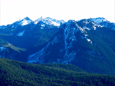
North Eagle Peak
A beautiful summit in close proximity to Longmire with commanding views of the south side of Mount Rainier and the Tatoosh Range. during the winter, spring, and early summer this peak can offer a great opportunity to practice and appreciate the safety afforded by rope team travel.
getting there
From SR-7 in Elbe, turn east onto SR-706, both known as the National Park Highway. Continue through the Nisqually Entrance of Mount Rainier National Park. Be prepared to pay the fee just after entering the park. Drive 6 miles to Longmire (2,757 ft).
In winter, ALL drivers in the park are required to carry snow chains or equivalent traction devices—this includes those with a 4-wheel or all-wheel drive vehicle.
About the peak
North Eagle Peak (5,884 ft) is 0.3 miles NNW of the highest Eagle Peak summit (5,958 ft). It has commanding views of the south side of Mount Rainier as well as the Tatoosh Range. Although a scramble in the late summer when conditions are dry, during the winter, spring, and early summer this peak can offer a great opportunity to practice and appreciate the safety afforded by rope team travel. The upper portions of this route are very steep such that arresting a fall on snow with an ice axe can be difficult, but by slinging trees and placing pickets while traveling as a rope team the consequences of this hazard can be reduced.
Ascent
From Longmire (2,757 ft) cross the bridge over the Nisqually River on foot. Ascend the Eagle Peak trail a short distance to reach a switchback at ~2,900 ft. From this switchback begin cross country travel on a traverse to the NNE through undergrowth affording the best progress. Cross a stream bed after 0.2 miles of cross country travel (it may be dry), and a second stream bed after another 0.3 miles (it may also be dry). Ascend the forested ridge forming the northern bank of this second stream, passing through a cliff band at ~3,900 ft to finally reach an altitude of ~4,200 ft. Continue ascending with an approximate bearing 59 degrees true through terrain affording the best progress to ~5,100 ft. At this point rope up and begin using pickets, trees, and other natural features to protect a fall. The route will meander back and forth near the west ridge of North Eagle Peak. For the final 60 feet of rock scrambling a belay from the summit can be comforting in winter conditions. Loose rock in this section motivates party members waiting to ascend to keep out of the fall line of the climber above them.
Descent
Descend the ascent route taking advantage of the same natural protection used during the ascent to ~5,100 ft and unrope. At this point begin a descending traverse to the south to quickly cross a major gully/terrain trap. After crossing this depression continue traversing in a southerly direction at ~4,900 feet elevation that undulates over several forested ridges. Pass an open flat area where tarns can provide water in the summer. Continue the traverse south and descend a bit to reach the Eagle Peak trail between ~4,700 ft and ~4,800 ft of elevation. Hike the trail back to Longmire.
- Suitable Activities: Climbing
- Climbing Category: Basic Alpine
- Seasons: January, February, March, April, May, December
- Weather: View weather forecast
- View avalanche forecast.
- Difficulty: Basic Alpine Climb
- Length: 6.0 mi
- Elevation Gain: 3,200 ft
- 5,884 ft
- Land Manager: Mount Rainier National Park
- Parking Permit Required: National Park Entrance Fee
- Recommended Party Size: 8
- Maximum Party Size: 12
- Maximum Route/Place Capacity: 12
- USGS Mt Rainier West
- Green Trails Mount Rainier Wonderland No. 269SX
There are no resources for this route/place. Log in and send us updates, images, or resources.
