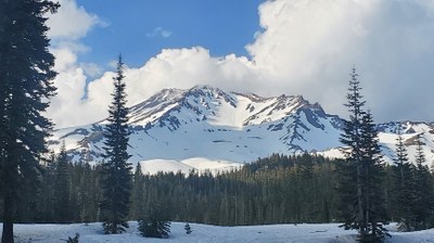
Mount Shasta/Avalanche Gulch
A Grade II, Class 3 snow climb on one of California's Cascade volcanoes. This is also a good back country ski trip.
getting there
There are three trailheads that serve this route—Sand Flat, Bunny Flat and Ski Bowl. From the town of Mount Shasta drive northeast on Lake Street and turn left onto Everett Memorial Highway. The turn offs to Sand Flat are at 10.5 and 11 miles, Bunny Flat is at 2 miles and Ski Bowl is at 14.5 miles.
Equipment
Helmet, ice axe, and crampons.
Ski descent
Ski down the ascent route or consider skiing down the West Face Gully and traversing back to Horse Camp.
notes
- Guidebook: Best Climbs Cascade Volcanoes by Jeff Smoot (Falcon Guides 2012).
- Consider bagging Lassen Peak along with Mount Shasta. It's 5-mile round trip day hike with 2,000 feet of elevation gain.
- Suitable Activities: Backcountry Skiing, Climbing, Scrambling
- Climbing Category: Basic Alpine
- Seasons: May, June, July, August
- Weather: View weather forecast
- Difficulty: Basic Alpine Climb, M2 Advanced Ski, Strenuous 5, Technical 4
- Length: 12.0 mi
- Elevation Gain: 7,200 ft
- 14,162 ft
-
Land Manager:
Shasta-Trinity National Forest
Mount Shasta Wilderness, Mount Shasta Ranger District (STNF)
- Parking Permit Required: None
- Recommended Party Size: 12
- Maximum Party Size: 12
- Maximum Route/Place Capacity: 12
- Wilderness Press Mt. Shasta Wilderness
- USGS Mt Shasta, CA
- USGS McCloud, CA
This is a list of titles that represent the variations of trips you can take at this route/place. This includes side trips, extensions and peak combinations. Not seeing a title that fits your trip? Log in and send us updates, images, or resources.
- Mount Shasta & Lassen Peak
- Mount Shasta/Avalanche Gap & Lassen Peak
| Name/Description |
|---|
| Lassen Peak Trail Guide A trail guide from the National Park Service for hiking the the summit of Lassen Peak. |
