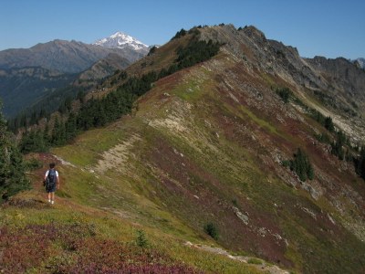
Poet Ridge
A scenic hike to the summit of a former lookout site among the Poet peaks. There are great views of North Cascade peaks and wildflower fields. Both approaches are about the same length, but the one from Little Wenatchee Ford is steeper and has more elevation gain. From Poe Mountain, Longfellow Mountain is a moderate scramble on Poet Ridge. From Irving Pass scramble the rarely climbed Irving Peak.
getting there
Little Wenatchee Ford
Drive US-2 to Coles Corner (15 miles west of Leavenworth) and turn north onto SR-207. Drive 2.4 miles to an intersection just after crossing the Wenatchee River. Bear left onto North Shore Road. In 7.6 miles, it become Forest Road 65. Continue 14 miles to the road's end and the Little Wenatchee Ford Trailhead (3,025 ft).
Irving Pass
Drive US-2 to Coles Corner (15 miles west of Leavenworth) and turn north onto SR-207. Drive 2.4 miles to an intersection just after crossing the Wenatchee River. Bear left onto North Shore Road. In 7.6 miles, it become Forest Road 65. Continue 7.7 miles, turn right onto Forest Road 6504, and continue 6.3 miles to the Irving Pass Trailhead (4,150 ft).
on the trail
Poe Mountain (6,015 ft) via Little Wenatchee River
6 miles round trip, 3,000 feet of elevation gain
Hike the Little Wenatchee River Trail, No. 1525 for ~0.2 mile and turn right onto the Poe Mountain Trail, No. 1520. Hike a steep 2.5 miles and 2,500 feet of elevation gain to a junction. To the right is the Little Wenatchee Ridge Trail, No. 1543, which leads to Irving Pass. Turn left, circle around Poe Mountain and up to its summit via its north ridge.
Poe Mountain (6,015 ft) via Irving Pass
6 miles round trip with 2,250 feet of elevation gain
This is a less steep and strenuous path to Poe Mountain than the one from Little Wenatchee Ford. Hike the Irving Pass Trail 0.6 miles and turn left onto the Little Wenatchee Ridge Trail, No. 1543. Hike 2.1 miles and meet the Poe Mountain Trail. Continue straight, circle around Poe Mountain and up to its summit via its north ridge.
scramble Routes
Longfellow Mountain (6,577 ft)
10 miles round trip, 3,800 feet of elevation gain
difficulty: Strenuous 3, Technical 2
Hike the Little Wenatchee Trail for ~0.2 mi, then take the right fork on Poe Mountain Trail. Follow this trail to just north of the Poe Mountain summit, then follow climbers trail along the spine of Poet's Ridge, shown on maps as Wenatchee Ridge. The climber's trail drops to the west side of ridge before reaching Point 6540 and into a boulder-filled basin (~6,100 ft). Ascend extremely loose rock to the 6,200-foot saddle on the north-northwest ridge. From here, it is an easy walk up to summit.
Irving Peak
4 miles round trip, 1,800 feet of elevation gain
difficulty: strenuous 2, technical 3
Hike the trail to Irving Pass. From there, the route follows intermittent game trails along the ridge or its south side. Near the summit it traverses on its south side, then ascends to the southeast ridge shortly before the top. There is some exposure in places, but plentiful "vegetable belays" are available. It is possible to extend the trip to a slightly higher summit about a half mile to the north, but that summit appears to be forested so the views are probably not as good as on Irving Peak.
- Suitable Activities: Scrambling
- Seasons: May, June, July, August, September, October
- Weather: View weather forecast
- View avalanche forecast.
- Difficulty: Strenuous, Moderate, Strenuous 3, Technical 2, Strenuous 2, Technical 3
- Length: 10.0 None
- Elevation Gain: 3,800 ft
- 6,577 ft
-
Land Manager:
Okanogan-Wenatchee National Forests
Henry M Jackson Wilderness, Wenatchee River Ranger District (OWNF)
- Parking Permit Required: Northwest Forest Pass
- Recommended Party Size: 12
- Maximum Party Size: 12
- Maximum Route/Place Capacity: 12
- Green Trails Benchmark Mtn No. 144
- USGS Poe Mountain
This is a list of titles that represent the variations of trips you can take at this route/place. This includes side trips, extensions and peak combinations. Not seeing a title that fits your trip? Log in and send us updates, images, or resources.
- Longfellow Mountain
- Poe Mountain
- Poe Mountain via Irving Pass
- Irving Peak
| Name/Description |
|---|
| Trip Segments for Longfellow Mountain Data on the route, broken up and detailed. |
| Map for Longfellow Mountain Route CalTopo map with GPS track of route. |
| Elevation Profile of Longfellow Mountain Route Profile of elevation gain/loss on route. |
