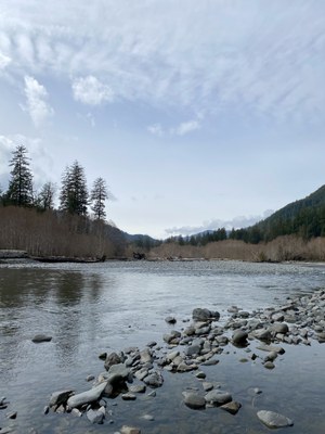
Hoh River
Hike or backpack in one of the world’s most famous temperate rain forests. It's in Washington State's Olympic Mountains, where even the air seems green, and is one of the world’s quietest places. Highlights of a trip include the river, rain forests, tremendous trees, likely Roosevelt Elk sightings, and perhaps even a visit to "One Square Inch of Silence."
Getting There
Drive US-101 through Port Angeles to 12.5 mi south of the town of Forks. Turn east onto the Hoh River Road and drive 19 miles to the end of the road at the Hoh Ranger Station and Campground in Olympic National Park (578 ft).
On the Trail
The Hoh River Trail is about 17.6 miles long and ends at Glacier Meadows. There are several camps along the way that support trips of various lengths and difficulties including day hikes and backpacks from one to many nights.
- Mount Tom Creek (700 ft) - 3 miles one way with 100 feet of elevation gain.
- Five Mile Island (800 ft) - 5.1 miles one way with 200 feet of elevation gain.
- Happy Four (800 ft) - 5.8 miles one way with 200 feet of elevation gain.
- Olympus Guard Station (950 ft) - 9.2 miles one way with 350 feet of elevation gain.
- Lewis Meadows (1,000 ft) - 10.8 miles one way with 400 feet of elevation gain.
- Martin Creek Stock Camp (2,450 ft) - 15 miles one way with 1,850 feet of elevation gain.
- Elk Lake Camp (2,600 ft) - 15.3 miles on way with 2,000 feet of elevation gain.
- Glacier Meadows Camp (4,300 ft) - 17.6 miles one way with 3,700 feet of elevation gain.
From Glacier Meadows Camp two informal trails lead to views of the Blue Glacier. The true summit of Mount Olympus is just out of sight.
- Terminal Moraine Trail - 0.4 miles and 800 feet of elevation gain.
- Lateral Moraine Trail - 0.8 miles and 800 feet of elevation gain.
Information for Leaders
Scheduling & Permits
- This route allows multiple bookings. Please check scheduled trips listed below in the "Activities" tab to see if there is another group already booked on the same day. Leaders are expected to contact the leader(s) of existing trips to ensure there are no concerns or conflicts, according to The Mountaineers Outdoor Ethics Policy. Please review our Group Size & Multiple Bookings page for guidance.
- Suitable Activities: Backpacking, Day Hiking
- Seasons: July, August, September, October
- Weather: View weather forecast
- Difficulty: *Varies*
- Length: 17.6 mi
- Elevation Gain: 3,700 ft
- 4,325 ft
- Land Manager: Olympic National Park
- Parking Permit Required: National Park Entrance Fee
- Recommended Party Size: 12
- Maximum Party Size: 12
- Maximum Route/Place Capacity: 12
- Custom Correct Seven Lakes Basin - Hoh
- Green Trails Seven Lakes Basin/Mt Olympus Climb No. 133S
- Green Trails Mt Tom No. 133
- Green Trails Mount Olympus No. 134
- Custom Correct Mount Olympus Climber's Map
This is a list of titles that represent the variations of trips you can take at this route/place. This includes side trips, extensions and peak combinations. Not seeing a title that fits your trip? Log in and send us updates, images, or resources.
- Hoh River to Mount Tom Creek
- Hoh River to Five Mile Island
- Hoh River to Happy Four
- Hoh River to Olympus Ranger Station
- Hoh River to Lewis Meadows
- Hoh River to High Hoh Bridge
- Hoh River to Martin Creek
- Hoh River to Elk Lake
- Hoh River to Glacier Meadows
There are no resources for this route/place. Log in and send us updates, images, or resources.
