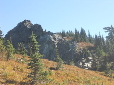
Dewey Peak
Dewey Peak is a Class 3 climb.
getting there
Drive SR-410 to near Chinook Pass.
APPROACH
Take either branch of Naches Loop Trail. If starting at Tipsoo, intersect with Pacific Crest Trail (PCT) south/southeast of Naches Peak and follow PCT down 900 ft to Dewey Lake. There is a permit station shortly when leaving Mount Rainier National Park.
When first arriving at Dewey Lake, there is a trail branch which heads to your left (east) through a camping area on north end of lake and on to west side of lake. PCT continues straight, skirting southwest side of Dewey Lake.
From the south end of the small lake lying to west of Dewey Lake, look for an unmaintained footpath heading west/southwest around west side of this small lake. This footpath leaves PCT to your right when first arriving at Dewey Lake elevation (in same vicinity as previously described fork heading off to your left). If you miss this footpath continue down PCT a short way and bear to your right on another unmaintained footpath (staying on a south bearing) to get to South end of the small lake.
Once at the south end of the small lake go east a bit looking for climbers’ trails/game trails heading uphill (due south) toward Dewey Peak – You cannot head uphill directly from the south end of lake as it is buttressed with small cornices and cliffs. Just east of the buttressed zone is a small drainage valley which you should also avoid as it which turns into a ravine as you ascend. You need to head east enough to be on the east side of this gully/drainage. It is bushwhacking for the first 700 ft of ascent finding the path of least resistance but generally staying on a 180°? true bearing heading uphill.
At about 5,800 ft you will break the tree line and be in a relatively flat/gentle rocky bowl. Stay on a southerly bearing to ascend to the ridgeline leading to the summit. If you bear to far left (southeast) you will end up at a cliff underneath summit block. So if you err, err to your right a bit. Ascend to this ridgeline leading to Dewey where you will find a climbers trail following ridge to the summit block.
As you near the summit block, you must cross a steep rocky gully/cirque near the summit. After crossing this gulley face a bit further you will be just below the summit block. Scramble up a few ft of loose rock debris to the base of the summit block.
ASCENT ROUTE
You should be at the west/southwest side of summit block which looks pretty imposing. Rotate counterclockwise (toward northwest), gaining a little elevation, around base of summit block to the top of a rock filled gully (previously crossed below). This face is generally used for the scramble type climbs to the summit. It is about 25 m to summit from this point so if you plan to rappel off, It would be good to have a 60 m rope.
The rock here is generally unreliable. As you get higher on the face you will encounter rock embedded in dirt! Be sure to test all holds. The easiest route starts at the top of the gully (which is also a small saddle) and traverses right upward across the face, then a couple vertical moves (which are the crux) before gentling out a bit on broken rock and dirt traversing back left to the summit. Problem is the further right you traverse the more exposure encountered!
Slightly more challenging rock climbing is encountered by not traversing so far to the right and lessening the exposure. Reliable Belay anchors on the summit are hard to come by and a few feet away from the route.
The summit is plenty large enough for a party of five to eight people.
DESCENT ROUTE
Reliable rappel anchors on the summit are difficult to find. Descending a few feet down the route from the summit were a couple horns which we used for a rappel anchor (one backed up by another). As indicated the rappel was about 75 ft from this point.
NOTES
There is an excellent lunch spot with great views and a large rock pedestal to sit on just down from summit block before crossing the face of the rocky gully on descent. Drop your packs here when going up.
- Suitable Activities: Climbing
- Climbing Category: Basic Alpine
- Seasons: May, June, July, August, September, October
- Weather: View weather forecast
- Difficulty: Basic Alpine Climb
- Length: 7.5 mi
- Elevation Gain: 3,100 ft
- 6,710 ft
-
Land Manager:
Mount Rainier National Park
William O Douglas Wilderness
- Parking Permit Required: National Park Entrance Fee
- Recommended Party Size: 12
- Maximum Party Size: 12
- Maximum Route/Place Capacity: 12
- USGS Cougar Lake
There are no resources for this route/place. Log in and send us updates, images, or resources.
