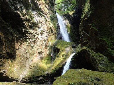
Davis Creek
A classic Pacific Northwest canyon, Davis Creek is an intermediate canyon in late summer, rated at v3a4III. With steep walls and lush green corridors, it has the added bonus of nearly no hiking with a short car shuttle.
GETTING THERE
From Eatonville, drive US-12 through Randle. About 6 miles east of Randle, turn left onto Davis Creek Road. This road is paved initially, and the pavement dead-ends at the creek (it appears as though there once was a bridge crossing the creek). This is the exit; leave a car here (1,000 ft). To get to the drop in, drive 1.5 miles up Forest Road 63. At 0.6 miles, cross a bridge that provides a good view of the final rappel. Check water levels carefully at this point (see ropewiki). If the water levels are safe, continue 0.9 miles up the road to a large grassy pull-out on the right and park here (1,600 ft).
APPROACH
Suit up at the cars, becasue the approach is less than 5 minutes through the woods. Enter the woods on the left side of the road (opposite the grassy parking area), and head straight to the creek. No trail exists, but the underbrush is minimal and the walking is easy. Look for a tree with webbing on it and rappel into the creek.
DESCENT
Davis Creek has 8-10 rappels, depending on how you choose to navigate the obstacles. Three of the rappels have recirculating pools that are noticeable, though not difficult, even at moderate-low water. They can be dangerous and 0require advanced whitewater skills at high water (a5). Be diligent about checking water levels at the bridge, because once you've completed Rappel 3, you must complete the canyon.
- Rappel 1: 20 feet (6 m) off a bolt DCR (Down Canyon Right). A short but awkward rappel.
- Rappel 2: 15 feet (5 m) off a log jam. It is possible to rappel through the log jam or up and over, depending on water flow.
- Rappel 3: 30 feet (10 m) off a tree DCR. This rappel provides roped access to the top of Rappel 4. At low water, it's possible to down climb rather than rappel.
- Rappel 4: 120 feet (40 m) off bolts DCR. This is upper Davis Creek Falls and is a 2-stage rappel. The fall line is not fully visible from the anchors, so set the rope short, and have the first rappeller set the rope length.
- Rappel 5: 15 feet (5 m) from a log jam.
- Rappel 6: 30 feet (9 m) from a two-bolt anchor DCR into "swirling pothole #1". At moderate to low water, navigating the logs may be the most challenging part.
- Rappel 7: 20 feet (6 m) from a two-bolt anchor DCR into "swirling pothole #2". This pothole has a clockwise recirculation that can feel strong. At moderate to low water, a little willpower will get you up and out of the pothole, and swimming DCL can help as well.
- Rappel 8: 70 feet (21 m) from two bolts DCR. This rappel is slippery, in the flow, and ends in a hydraulic. At moderate-low levels, it is challenging, but not dangerous. It is also possible to descend DCL (Down Canyon Left) of the flow on ledgy terrain. This risks a pendulum, but the terrain is easy. There is a small ledge about 2 feet from the bottom from which you can get off rope and jump towards the channel, avoiding the hydraulic altogether.
- Down climb 15 feet: use partner assist or scootch across a new log (as of 2018).
- Rappel 9: 15 feet (8 m) from a two-bolt anchor DCL.
- Jump: 8 feet into a pool. Body belay (meat anchor) someone first to check that no boulders are in the pool below.
EXIT
After the final jump, the canyon opens up quickly. Ascend the scree slope DCR to access Davis Creek Road and the parking area.
EQUIPMENT
Standard canyoning gear including replacement webbing and quick links.
TRIP PROFILE
- Rappels: 8-10
- Longest Rappel: 120 feet
- Approach: ~0.1 mile
- Exit: ~0.1 mile
- Time: 3-5 hours total
NOTES
- This canyon is rated v3a4III at moderate-low water levels, and v4a5III in early to mid-season.
- For more information and recent trip reports from the community, visit the Davis Creek listing at ropewiki.
- Suitable Activities: Canyoning
- Seasons: August, September
- Weather: View weather forecast
- Difficulty: Intermediate Canyon
- Length: 1.0 mi
-
Land Manager:
Gifford Pinchot National Forest
Cowlitz Valley Ranger District (GPNF)
- Parking Permit Required: Northwest Forest Pass
- Recommended Party Size: 6
- Maximum Party Size: 12
- Maximum Route/Place Capacity: 12
- Green Trails Randle No. 301
- USGS Purcell Mtn
There are no resources for this route/place. Log in and send us updates, images, or resources.
