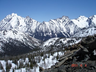
Navaho Pass & Peak
Hike the Stafford Creek Trail to Navaho Pass or scramble Navaho Peak, Little Navaho (aka Freedom Peak), and/or Three Brothers in the Teanaway Area.
GETTING THERE
Take Exit 85 off of I-90, near Cle Elum. Drive six miles on State Route 970 to the Teanaway River Road. Turn left immediately after crossing the Teanaway River - there is a left turn lane onto this road. Follow Forest Road 9737 (North Fork Teanaway River Road) to 29 Pines Campground. Take the right fork just past the campground, continuing on Forest Road 9737. Then turn right on Forest Road 9703 (Stafford Creek Road) and drive to the Stafford Creek Trailhead (3,100 ft).
on the trail
navaho pass (6,000 ft)
11 miles round trip, 3,000 feet of elevation gain, difficulty: strenuous
Hike the Stafford Creek Trail to Navaho Pass.
APPROACH & ASCENT
Navaho Peak (7,233 ft)
14.0 miles, 4.123 feet of elevation gain, difficulty: strenuous 3, technical 2
Start on the Stafford Creek Trail. As you hike the trail, look for a prominent peak straight ahead. This not Navaho Peak, but Little Navaho Peak, a prominent peak southwest of Navaho Peak on the ridgeline. Follow the trail to a branch at 5,000 feet where you are in a bowl surrounded by Earl Peak on the left and Navaho Peak on the right. Scramble north up to the ridgeline at 6,000 feet. From here, walk the west ridge that angles around to the 7,223-foot summit.
Descent:Return by heading south until you reach the Stafford Creek Trail. Do not follow the southeast ridge all the way down to Little Navaho—there are cliffs below.
Alternative 1: Extend your trip by adding Little Navaho, 500 feet more elevation gain and one more mile. Little Navaho is also known as Freedom Peak.
Alternative 2: Hike the Standup Creek Trail to ridgeline on which Earl Peak sits. From the saddle, a short and easy ascent leads to Earl Peak. Return to saddle and follow the trail down into the basin and through meadows to the Stafford Creek Trail. From there ascend to Navaho Peak and return by hiking out the Stafford Creek Trail. This is a long and interesting day that involves a short car shuttle between the Stafford Creek and Standup Creek trailheads.
Alternative 3:A strong party can bag three summits by leaving Stafford Creek Trail at a dry stream bed at 2.5 miles. Scramble scree and heather slopes to Little Navaho (not shown by that name on map). Drop down into the basin (often steep snow until mid-June) and head cross-country to the Three Brothers, an easy ridge walk. Descend again and then scramble snow or follow a way trail to summit of Navaho Peak. Descend to Navaho Pass and hike out the Stafford Creek Trail.
Three Brothers (7,303 ft)
11 miles round trip, 5,100 feet of elevation gain, difficulty: strenuous 5, technical 2
Hike the Stafford Creek Trail to 4,800 ft (3.5 mi) just before crossing a drainage. Leave the trail and head easterly following the drainage to the saddle at 6,000 ft. Ascend about 75 ft northerly to avoid cliffs (or drop to basin if snow or gravel is too hard for safe travel) and traverse east around the end of the ridge. When the saddle is in sight (Southwest Ridge of the Three Brothers), head for the saddle at approximately 6,040 ft, dropping about 150 ft. Then follow the Southwest Ridge to the summit.
Information for Leaders
- This route allows multiple bookings. Please check scheduled trips listed below in the "Activities" tab to see if there is another group already booked on the same day. Leaders are expected to contact the leader(s) of existing trips to ensure there are no concerns or conflicts, according to The Mountaineers Outdoor Ethics Policy.
- Suitable Activities: Backpacking, Day Hiking, Scrambling
- Seasons: July, August, September, October
- Weather: View weather forecast
- Difficulty: *Varies*, Strenuous, Strenuous 3, Strenuous 5, Technical 2
- Length: 11.0 mi
- Elevation Gain: 3,000 ft
- 6,000 ft
- Land Manager: Okanogan-Wenatchee National Forests
- Parking Permit Required: Northwest Forest Pass
- Recommended Party Size: 12
- Maximum Party Size: 12
- Maximum Route/Place Capacity: 12
- Green Trails Alpine Lakes East (Stuart Range) No. 208SX
- Green Trails Mt Stuart No. 209
- USGS Red Top Mtn
- USGS Enchantment Lakes
This is a list of titles that represent the variations of trips you can take at this route/place. This includes side trips, extensions and peak combinations. Not seeing a title that fits your trip? Log in and send us updates, images, or resources.
- Navaho Pass
- Navaho Peak
- Little Navaho
- Little Navaho Peak
- Freedom Peak
- Little Navaho aka Freedom Peak
- Navaho & Little Navaho Peaks
- Navaho & Freedom Peaks
- Three Brothers
- Little Navaho Peak & Three Brothers
- Freedom Peak & Three Brothers
- Freedom Peak, Navaho Peak & Three Brothers
- Navaho Peak, Little Navaho Peak & Three Brothers
There are no resources for this route/place. Log in and send us updates, images, or resources.
