Trip
Day Hike - Mount Zion
Mt. Zion (4261') summit from the east via the Snow Creek Trail #890. This is a short (2.4 miles one way) but steep (2000') hike through what we hope will be lots of rhododendron and wildflower blooms.
- Sat, May 20, 2023
- Kitsap Hiking & Backpacking Committee
- Day Hiking
- Adults
- Strenuous
- Challenging
- Mileage: 4.6 mi
- Elevation Gain: 2,000 ft
- High Point Elevation: 4,261 ft
- Pace: 1-2.5 mph/800-1000' per hour,
- 3 (5 capacity)
- FULL (1 capacity)
- Cancellation & Refund Policy
Meet at the Snow Creek #890 trailhead at 08:30. There is no privy at the trailhead. Northwest Forest Pass required.
Directions:
From Quilcene, WA head north on US Highway 101 for about 6 miles. Turn west onto Snow Creek Road. This county road becomes Forest Service Road #2850 after 6 miles. Once leaving the county road, take the second left onto Forest Service Road #2851. Take Forest Road 2851 for 3 miles. At the intersection of the 2851-090, stay left following 2851 to Snow Creek Trailhead.
For more information and an area map, see the ONF Snow Creek Trailhead page.
The pace will be relaxed but relentless (a kinder, gentler sort of relentless). We'll take the usual short breaks as required for pictures of moss and trees &c, but no longer breaks until lunch at the summit, unless necessary. It's still early in the season and you should expect mud and water on the trail in places. Also, bugs. They're back, so bring countermeasures just in case.
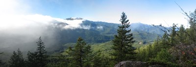
It'll be smooth sailing to the top where we get a pretty nice view and a leisurely lunch. Expect the trip to take about five hours, give or take. As of now, the weather looks good but it could be chilly and windy at the summit.
Required Equipment
- Navigation
- Headlamp
- Sun protection
- First aid
- Knife
- Fire
- Shelter
- Extra food
- Extra water
- Extra clothes
