Trip
Day Hike - Iron Bear
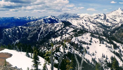
Iron Bear is a strenuous 6 1/2 mile 1900 ft elevation gain hike with early season wildflowers and lovely mountain views.
- Fri, May 21, 2021
- Foothills Hiking Committee
- Day Hiking
- Adults
- Strenuous
- Challenging
- Mileage: 8.0 mi
- Elevation Gain: 2,000 ft
- High Point Elevation: 5,489 ft
- Pace: 2 1/2
- 5 (7 capacity)
- Cancellation & Refund Policy
9:30a at the trailhead.
A recent trip report indicates the trail is almost snow free and the wildflowers are blooming. Join me for an early season workout and enjoy the well earned views and lunch at the top. https://www.wta.org/go-hiking/hikes/iron-bear.
Driving Directions - From I-90 take exit 85. Go left to cross the freeway, and make a right onto 970, passing the Twin Pines Drive-In. Hwy 970 veers left. 9.4 miles past the Twin Pines Drive-In, turn left onto Hwy 97 and continue for 9.9 miles.
Turn left onto FR 9714 for 2.7 miles to the end at the trailhead for Trail 1351. At the end of FR 9714 you will ford a stream just before you get to the trailhead. The last 200 yards of road is a bit dicey but you can park in several turnouts just before you get to the ford.
The Iron Creek trailhead is three miles from Hwy 97. No fee is required to park there, but there is no toilet available this trailhead.
This is a challenging early season hike with almost 2K gain in 3 miles and we will keep a slightly faster pace. Please be prepared to identify recent hiking experience with similar elevation gain and pace. Microspikes are recommended for the last section of trail.
Iron Bear & Miller Peak
-
Green Trails Alpine Lakes East (Stuart Range) No. 208SX
Green Trails Mt Stuart No. 209
Green Trails Liberty No. 210
USGS Red Top Mtn
USGS Liberty
USGS Enchantment Lakes
USGS Blewett - See full route/place details.
Required Equipment
The Ten Essentials + Microspikes
- Navigation
- Headlamp
- Sun protection
- First aid
- Knife
- Fire
- Shelter
- Extra food
- Extra water
- Extra clothes
