Trip
Day Hike - Easton Ridge
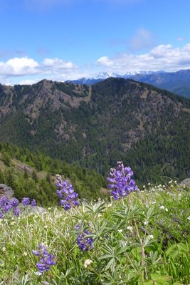
An early-morning out and back to the high point of Easton Ridge, with wildflowers and the potential for far-reaching views.
- Sat, Jun 18, 2022
- Seattle Hiking Committee
- Day Hiking
- Adults
- Moderate
- Moderate
- Mileage: 6.5 mi
- Elevation Gain: 2,400 ft
- High Point Elevation: 4,470 ft
- Pace: 2.0 mph
- 2 (4 capacity)
- FULL (2 capacity)
- Cancellation & Refund Policy
Meet at the trailhead at 7:00am geared up and ready to hike. Please note there are no restrooms at the trailhead.
Parking Pass: No parking pass is required.
Trailhead Directions:
From Seattle, drive east on I-90 to exit 70, signed for Lake Easton State Park. At the end of the ramp, turn left over the freeway. At the ‘T’, go left on Kachess Dam Road for one half mile, then right to stay on Kachess Dam Road (FR 4818). Travel another 0.8 mile, mostly on gravel, then turn right onto an unmarked one-lane dirt road. The road is rutted but driveable by most vehicles. At 0.6 mile, the dirt road ends at the trailhead. There is parking for about 10 vehicles, including along the shoulder.
- Google Maps link: Kachess Ridge Trailhead
The initial portion of this trail is fairly steep. We will be aiming for a pace of 2.0 mph but will ultimately stay together as a group.
A map of our route can be found here: Easton Ridge Trail
An email with further details will be sent to participants a few days before the trip.
Easton Ridge
-
Green Trails Alpine Lakes East (Stuart Range) No. 208SX
Green Trails Kachess Lake No. 208
Green Trails Easton No. 240 - See full route/place details.
Required Equipment
- Navigation
- Headlamp
- Sun protection
- First aid
- Knife
- Fire
- Shelter
- Extra food
- Extra water
- Extra clothes
