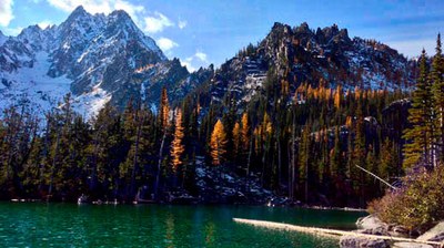
Trip
Backpack - Entiat River Meadows & High Country
Exploratory trip up the Entiat River trail. Flexibility required, as our destination will be influenced by snow and trail conditions. Participants in the Seattle Backpacking course are encouraged to request leader permission if interested.
- Thu, Jun 23, 2022 — Sat, Jun 25, 2022
- Seattle Backpacking Committee
- Backpacking
- Adults
- Strenuous
- Moderate
- Mileage: 28.0 mi
- Elevation Gain: 2,000 ft
- Pace: Moderate
- FULL (5 capacity)
- Cancellation & Refund Policy
Trailhead at the end of the Entiat River Road at 12:00 noon. (It's a long drive from Seattle)
We will explore the Entiat river trail system. Exact destination, mileage and elevation gain depends on trail and snow conditions. Trail is recently logged out past Myrtle Lake, conditions beyond that are unknown at the time of this posting. This area was heavily burned in the 2000s so be prepared for hiking in a burn area, which means lots of sun exposure (hopefully!). Not a lot of elevation gain on the main trail, but some side trails offer opportunities for going up higher if conditions allow.
Day 1: Long drive to the trailhead. Hike about 6 miles upriver and camp.
Day 2: Explorations, upriver, downriver, wherever looks promising.
Day 3: Hike out. Long drive back to the west side.
Bear can or Ursac required.
Entiat River Meadows & High Country
-
Green Trails Lucerne No. 114
Green Trails Holden No. 113 - See full route/place details.
Required Equipment
The Ten Essentials plus overnight gear which may include:
- Tent with footprint/ground tarp
- Stove and fuel
- Sleeping bag
- Sleeping pad
- Water filter
- Bear canister or Ursac
- Cooking pot/pan with plate and utensils
- Toilet paper and shovel or blue bag to deal with waste
