Trip
Day Hike - Oyster Dome & North Butte
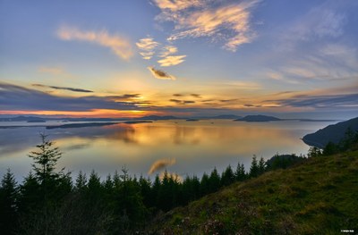
Join the Tacoma Singles for a hike to Oyster Dome and North Butte. This popular day hike travels through traditional Lummi Nation and Nooksack Tribal lands, leading to an overlook of the Samish Bay with views of the San Juan Islands. The hike travels beyond the crowded Oyster Dome overlook to the quieter North Butte overlook, with possible views of Mount Baker.
- Sat, Apr 27, 2019
- Tacoma Singles Activities Subcommittee
- Day Hiking
- Adults, Singles
- Moderate
- Easy
- Mileage: 6.5 mi
- Elevation Gain: 2,000 ft
- High Point Elevation: 2,200 ft
- Pace: 2 mph
- 1 (11 capacity)
- Cancellation & Refund Policy
Meet at the Samish Overlook parking area at 9 AM. Carpooling is highly encouraged, as this is a popular destination with limited trailhead parking. Please be prepared to stay together as a group and plan to be back at the trailhead by 2PM. Following the hike, hikers are welcome to have a post-hike bite to eat at the Mt. Vernon Co-op.
All trip members must agree to abide by Leave No Trace ethics, remembering to reduce contact with wild animals (please do not feed the wildlife). Review the LNT guidelines here: https://lnt.org/learn/7-principles
If the weather forecast becomes worse than a chance of rain, this hike will be rescheduled. Please check your email 3-4 days prior to the hike for more details and information about carpooling.
DIRECTIONS TO SAMISH OVERLOOK DAY USE AREA
From I-5, take exit 240 (Alger) and head west on Lake Samish Road. Take the first left onto Barrel Springs Road and travel 0.6 mile, to where there is a sign reading “Blanchard Forest Block”. Turn right on the dirt road and travel another 1.7 miles to a sign for “Samish Overlook”. Turn left and pass through the yellow gate (open one hour before sunrise to one hour past sunset) and continue 2.2 miles to the Samish Overlook Day Use Area. There is parking for 20 vehicles (day use only.) There are vault toilets, picnic tables and benches. A Discover Pass is required.
Trail Map: https://www.dnr.wa.gov/publications/amp_rec_blanchard_2012.pdf
HIKING ROUTE
We will begin the hike at the Samish Overlook parking area, following the brief Chuckanut connector to the Samish Bay trail, and briefly stop at the Oyster Dome overlook. Then we will continue past Lily Lake towards North Butte where we will stop for a longer break to enjoy the secluded viewpoint. To return to the trailhead, we will take Max’s shortcut and the Larry Reid trail.
Oyster Dome
-
USGS Bellingham South
USGS Bow
Trails of the Chuckanut Mountains
Chuckanut Mountain Recreation Map - See full route/place details.
Required Equipment
- Navigation
- Sun protection
- Insulation (extra clothing)
- Illumination
- First aid supplies
- Fire
- Repair kit and tools, including knife
- Nutrition (extra food)
- Hydration (extra water)
- Emergency shelter
